Approximate Location Map
Large Map »
Latitude: 53.1624 / 53°9'44"N
Longitude: -2.2109 / 2°12'39"W
OS Eastings: 385997
OS Northings: 362829
OS Grid: SJ859628
Mapcode National: GBR 12B.RV4
Mapcode Global: WHBC1.0SH0
Plus Code: 9C5V5Q6Q+XJ
Entry Name: 3, Chapel Street
Listing Date: 4 April 1975
Grade: II
Source: Historic England
Source ID: 1130497
English Heritage Legacy ID: 55865
ID on this website: 101130497
Location: Congleton, Cheshire East, Cheshire, CW12
County: Cheshire East
Civil Parish: Congleton
Built-Up Area: Congleton
Traditional County: Cheshire
Lieutenancy Area (Ceremonial County): Cheshire
Church of England Parish: Congleton Team
Church of England Diocese: Chester
Tagged with: House
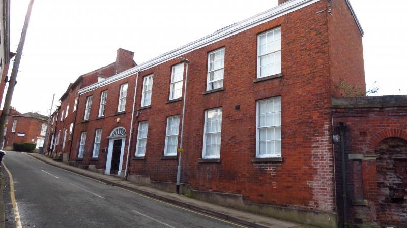
1.
5144 CHAPEL STREET STREET
(North Side)
SJ 8562 1/6 No 3
SJ 8662 3/6
II GV
2.
Early C19. Red brick with stone plinth; 2 storeys; 7 plain sash windows
with flat brick arches and stone sills; moulded wood pilaster doorcase
with side panels, elliptical fanlight with radiating glazing bars and
6-panelled door; moulded wood eaves; slates.
Nos 3 to 7 (odd) form a group.
Listing NGR: SJ8599762829
External links are from the relevant listing authority and, where applicable, Wikidata. Wikidata IDs may be related buildings as well as this specific building. If you want to add or update a link, you will need to do so by editing the Wikidata entry.


Other nearby listed buildings
