Latitude: 53.2081 / 53°12'29"N
Longitude: -2.7114 / 2°42'41"W
OS Eastings: 352581
OS Northings: 368128
OS Grid: SJ525681
Mapcode National: GBR 7K.1V5V
Mapcode Global: WH88B.BM2G
Plus Code: 9C5V675Q+6C
Entry Name: Church of St Phillip
Listing Date: 8 November 1985
Grade: II
Source: Historic England
Source ID: 1130533
English Heritage Legacy ID: 55745
ID on this website: 101130533
Location: St Philip's Church, Kelsall, Cheshire West and Chester, Cheshire, CW6
County: Cheshire West and Chester
Civil Parish: Kelsall
Built-Up Area: Kelsall
Traditional County: Cheshire
Lieutenancy Area (Ceremonial County): Cheshire
Church of England Parish: Kelsall St Philip
Church of England Diocese: Chester
Tagged with: Church building Gothic Revival
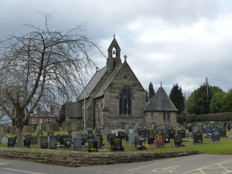
SJ 56 NW KELSALL C.P. CHESTER ROAD
(North Side)
3/41 Church of St Phillip.
II
Church: 1860 by T Bower of Nantwich. Rockfaced buff sandstone, Welsh
slate roof, red tile ridge. Decorated style. 4-bay nave, 2-bay
chancel, south porch, vestry and sanctus bellcote. Gabled south porch
has heavy 2-centred arched entrance on stout shafts with undressed
capitals. Similar doorcase behind on pairs of shafts contains pair of
doors with ornate hinges. Bays of nave and chancel divided by
buttresses; nave has 2-light windows with alternate quatrefoil and
trefoil plate tracery. Chancel has pairs of lancets with trefoil
heads. 3-light east window with sexfoils and a quatrefoil has a
label mould with plain rectangular stops. Similar 4-light west
window. On north side, vestry has hexagonal end with pyramidal roof.
Interior: tall and plain in ashlar. Ovolo-moulded rebated chancel
arch, the outer part on shaft to floor, the inner part on a stout
shaft sprung from a corbel at mid-height. Both have undressed
capitals. Plain font is a quatrefoil in section on 4 short shafts.
Listing NGR: SJ5258168128
External links are from the relevant listing authority and, where applicable, Wikidata. Wikidata IDs may be related buildings as well as this specific building. If you want to add or update a link, you will need to do so by editing the Wikidata entry.


Other nearby listed buildings