Latitude: 50.6096 / 50°36'34"N
Longitude: -2.4539 / 2°27'14"W
OS Eastings: 367978
OS Northings: 78976
OS Grid: SY679789
Mapcode National: GBR PY.DHDK
Mapcode Global: FRA 57RG.7V1
Plus Code: 9C2VJG5W+RC
Entry Name: 22 and 23, St Mary Street
Listing Date: 14 June 1974
Last Amended: 22 December 1997
Grade: II
Source: Historic England
Source ID: 1132634
English Heritage Legacy ID: 467891
ID on this website: 101132634
Location: Weymouth, Dorset, DT4
County: Dorset
Electoral Ward/Division: Melcombe Regis
Parish: Weymouth
Built-Up Area: Weymouth
Traditional County: Dorset
Lieutenancy Area (Ceremonial County): Dorset
Church of England Parish: Radipole and Melcombe Regis
Church of England Diocese: Salisbury
Tagged with: Building
WEYMOUTH
SY6778NE ST MARY STREET 873-1/23/295 (East side) 14/06/74 Nos.22 AND 23 (Formerly Listed as: ST MARY STREET (East side) Nos.19-23 (Consecutive))
GV II
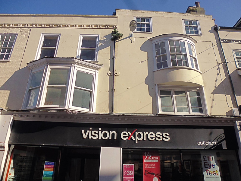
Two houses in row, with shops. Late C18 or early C19. Painted brick (No.22) or rendered (No.23), slate roofs. 3 storeys and attic. At second floor are two 12-pane and 2 plain sashes, above an 8:12:8-pane oriel with dentils, and a canted oriel with plain sash to bold cornice. The shop front to No.22 continues the deep fascia and pilaster treatment of the adjoining No.21 (qv), but No.23 has a deep C20 fascia over plate-glass frontage (which continues across No.24 (qv)). A simple cornice of a plain band on paired brick 'dentils', with blocking course and parapet. INTERIOR not inspected. (RCHME: Dorset, South-East: London: 1970-: 351).
Listing NGR: SY6797978978
External links are from the relevant listing authority and, where applicable, Wikidata. Wikidata IDs may be related buildings as well as this specific building. If you want to add or update a link, you will need to do so by editing the Wikidata entry.


Other nearby listed buildings