Latitude: 53.4521 / 53°27'7"N
Longitude: -1.299 / 1°17'56"W
OS Eastings: 446652
OS Northings: 395271
OS Grid: SK466952
Mapcode National: GBR MXCJ.K7
Mapcode Global: WHDDD.0HQC
Plus Code: 9C5WFP22+VC
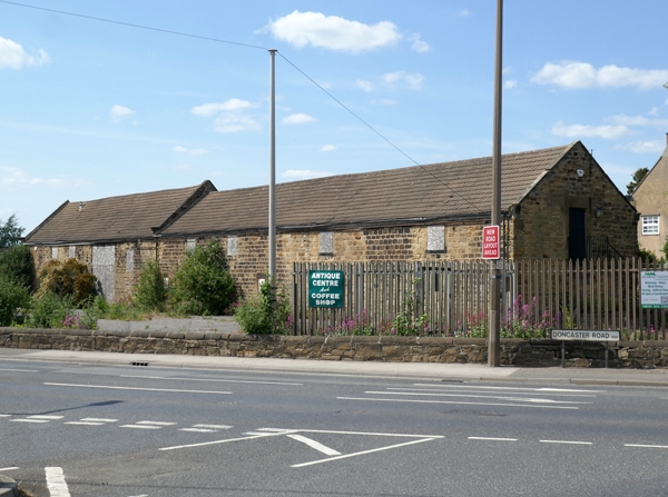
Entry Name: Cartshed Granary and Stable Building Approximately 20 Metres to South of Chestnut Tree Farmhouse
Listing Date: 21 August 1985
Grade: II
Source: Historic England
Source ID: 1132784
English Heritage Legacy ID: 335547
ID on this website: 101132784
Location: Thrybergh, Rotherham, South Yorkshire, S65
County: Rotherham
Civil Parish: Thrybergh
Built-Up Area: Rotherham
Traditional County: Yorkshire
Lieutenancy Area (Ceremonial County): South Yorkshire
Church of England Parish: Thrybergh St Leonard
Church of England Diocese: Sheffield
Tagged with: Granary Carriage house
SK49ME THRYBERGH DONCASTER ROAD (west side)
6/38 Cart shed, granary and stable building approximately 20 metres to south of Chestnut Tree Farmhouse
II
Cartshed, granary and stable now garage and store. Dated 1816. Coursed, horizontally-tooled sandstone, renewed tile roof. Elongated range: 5-entry cartshed to left, 3-door stable to right, granary and loft over. 2 storeys. Segmental-arched, cart-entry arcade has outermost reveals quoined, otherwise monolithic piers, shared springers and herringbone-tooled voussoirs. Left entry has boarded door, entries 3 and 4 have horizontal-sliding door. Stable to right has bonded stone surrounds to 3 doorways, boarded door to centre, outer doorways blocked and now windows. Two 1st-floor windows above cartshed: horizontal-sliding sashes with glazing bars in square-faced surrounds. Shaped kneelers and gable copings to left. Rear: blocked 1st-floor windows to granary above cartshed, blocked ground-floor windows and 1st-floor openings to stable part. Left return: stone steps to granary door, dated lintel.
Listing NGR: SK4665295271
External links are from the relevant listing authority and, where applicable, Wikidata. Wikidata IDs may be related buildings as well as this specific building. If you want to add or update a link, you will need to do so by editing the Wikidata entry.


Other nearby listed buildings