Latitude: 53.8083 / 53°48'29"N
Longitude: -1.8335 / 1°50'0"W
OS Eastings: 411063
OS Northings: 434679
OS Grid: SE110346
Mapcode National: GBR HSMD.VK
Mapcode Global: WHC97.TJ3V
Plus Code: 9C5WR558+8J
Entry Name: 31-38, Prune Park Road
Listing Date: 9 August 1983
Grade: II
Source: Historic England
Source ID: 1132901
English Heritage Legacy ID: 337033
ID on this website: 101132901
Location: Stony Lane, Bradford, West Yorkshire, BD15
County: Bradford
Civil Parish: Sandy Lane
Built-Up Area: Bradford
Traditional County: Yorkshire
Lieutenancy Area (Ceremonial County): West Yorkshire
Church of England Parish: Allerton St Peter
Church of England Diocese: Leeds
Tagged with: Building
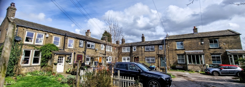
1.
5111 PRUNE PARK ROAD
Allerton
Cliffe View
(Nos 31 to 38 (consec))
SE 1134 25/978
II
2.
Circa 1820-30 L plan block of sandstone "brick" cottages. Stone slate roofs
with corniced chimneys. Two light square mullion windows with single light
over doorways, all in squared surrounds. Squared jamb doorways.
Listing NGR: SE1106334679
External links are from the relevant listing authority and, where applicable, Wikidata. Wikidata IDs may be related buildings as well as this specific building. If you want to add or update a link, you will need to do so by editing the Wikidata entry.


Other nearby listed buildings