Approximate Location Map
Large Map »
Latitude: 53.6464 / 53°38'47"N
Longitude: -1.783 / 1°46'58"W
OS Eastings: 414444
OS Northings: 416677
OS Grid: SE144166
Mapcode National: GBR HVZ8.SL
Mapcode Global: WHCB1.LL5Y
Plus Code: 9C5WJ6W8+HR
Entry Name: 14, Chancery Lane
Listing Date: 29 September 1978
Grade: II
Source: Historic England
Source ID: 1134314
English Heritage Legacy ID: 339668
ID on this website: 101134314
Location: Huddersfield, Kirklees, West Yorkshire, HD1
County: Kirklees
Electoral Ward/Division: Newsome
Parish: Non Civil Parish
Built-Up Area: Huddersfield
Traditional County: Yorkshire
Lieutenancy Area (Ceremonial County): West Yorkshire
Church of England Parish: Huddersfield St Peter
Church of England Diocese: Leeds
Tagged with: Building
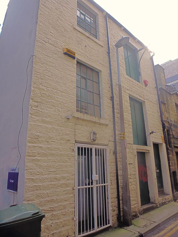
CHANCERY LANE
1.
5113
(East Side)
No 14
SE 1416 NW 1/327
II
2.
Early C19. Warehouse. Hammer-dressed stone. Pitched stone slate roof. 3
storeys. Stone brackets to gutter. One range of industrial windows with glazing
bars. One range of planked loading doors with winch hoist. Double doors with
4 sunk panels.
Listing NGR: SE1444416677
External links are from the relevant listing authority and, where applicable, Wikidata. Wikidata IDs may be related buildings as well as this specific building. If you want to add or update a link, you will need to do so by editing the Wikidata entry.


Other nearby listed buildings
