Approximate Location Map
Large Map »
Latitude: 53.7013 / 53°42'4"N
Longitude: -1.7129 / 1°42'46"W
OS Eastings: 419050
OS Northings: 422803
OS Grid: SE190228
Mapcode National: GBR JTGM.YX
Mapcode Global: WHC9W.N7JB
Plus Code: 9C5WP72P+GR
Entry Name: Barn Adjoining Number 120
Listing Date: 2 September 1981
Grade: II
Source: Historic England
Source ID: 1134592
English Heritage Legacy ID: 341004
ID on this website: 101134592
Location: Roberttown, Kirklees, West Yorkshire, WF15
County: Kirklees
Electoral Ward/Division: Liversedge and Gomersal
Parish: Non Civil Parish
Built-Up Area: Liversedge
Traditional County: Yorkshire
Lieutenancy Area (Ceremonial County): West Yorkshire
Church of England Parish: Roberttown All Saints
Church of England Diocese: Leeds
Tagged with: Barn
SE 12 SE SPENBOROUGH MB CHURCH ROAD
ROBERTTOWN
3/98
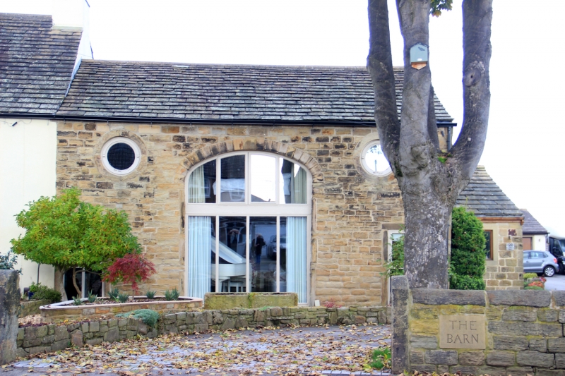
2.9.81 Barn adjoining No. 120
G.V. II
Barn, part of group. Early C.19. Hammer dressed stone. Stone slate
roof. Large, central doorway with elliptical arch. To left and right,
at high level is round pitch-hole. Small part blocked doorway to right.
Listing NGR: SE1905022803
External links are from the relevant listing authority and, where applicable, Wikidata. Wikidata IDs may be related buildings as well as this specific building. If you want to add or update a link, you will need to do so by editing the Wikidata entry.


Other nearby listed buildings
