Approximate Location Map
Large Map »
Latitude: 53.5877 / 53°35'15"N
Longitude: -1.8503 / 1°51'1"W
OS Eastings: 410006
OS Northings: 410131
OS Grid: SE100101
Mapcode National: GBR HVJY.6N
Mapcode Global: WHCBD.K23Y
Plus Code: 9C5WH4QX+3V
Entry Name: Kissing Gate and Gate Piers at Junction with Footpath Number 44
Listing Date: 1 December 1978
Grade: II
Source: Historic England
Source ID: 1134651
English Heritage Legacy ID: 340840
ID on this website: 101134651
Location: Meltham, Kirklees, West Yorkshire, HD9
County: Kirklees
Civil Parish: Meltham
Built-Up Area: Meltham
Traditional County: Yorkshire
Lieutenancy Area (Ceremonial County): West Yorkshire
Church of England Parish: Christ the King, Meltham
Church of England Diocese: Leeds
Tagged with: Architectural structure
SE 11 SW CALMLANDS ROAD
(Meltham)
2/4
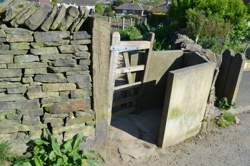
Kissing gate and gate piers
December 1978 at junction with footpath
No. 44
II
Kissing gate to footpath. Probably early to mid C19. Two upright
stone slabs and one post with wooden gate on iron hinges. Stone paving.
Listing NGR: SE1000610131
External links are from the relevant listing authority and, where applicable, Wikidata. Wikidata IDs may be related buildings as well as this specific building. If you want to add or update a link, you will need to do so by editing the Wikidata entry.


Other nearby listed buildings
