Approximate Location Map
Large Map »
Latitude: 53.5841 / 53°35'2"N
Longitude: -1.7898 / 1°47'23"W
OS Eastings: 414014
OS Northings: 409744
OS Grid: SE140097
Mapcode National: GBR HVYZ.9X
Mapcode Global: WHCBF.G5YP
Plus Code: 9C5WH6M6+J3
Entry Name: 125, Thong Lane
Listing Date: 4 August 1983
Grade: II
Source: Historic England
Source ID: 1134784
English Heritage Legacy ID: 340542
ID on this website: 101134784
Location: Netherthong, Kirklees, West Yorkshire, HD9
County: Kirklees
Civil Parish: Holme Valley
Built-Up Area: Holmfirth
Traditional County: Yorkshire
Lieutenancy Area (Ceremonial County): West Yorkshire
Church of England Parish: Netherthong All Saints
Church of England Diocese: Leeds
Tagged with: Building
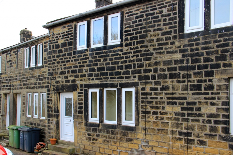
SE 10 NW THONG LANE
4/315 (Netherthong)
No 125
GV
II
Part of terrace. Early C19. Hammer dressed stone. Quoins. Stone slate roof.
Moulded stone brackets to gutter. Two storeys. Ground floor: entrance and one
3-light stone mullioned window. First floor: one 3-light stone mullioned window.
Altered rear elevation.
Listing NGR: SE1401409744
External links are from the relevant listing authority and, where applicable, Wikidata. Wikidata IDs may be related buildings as well as this specific building. If you want to add or update a link, you will need to do so by editing the Wikidata entry.


Other nearby listed buildings
