Latitude: 53.6044 / 53°36'15"N
Longitude: -1.7917 / 1°47'30"W
OS Eastings: 413882
OS Northings: 412000
OS Grid: SE138120
Mapcode National: GBR HVXR.XN
Mapcode Global: WHCB7.GN1N
Plus Code: 9C5WJ635+Q8
Entry Name: Honley Wells
Listing Date: 16 January 1967
Grade: II
Source: Historic England
Source ID: 1134905
English Heritage Legacy ID: 340311
ID on this website: 101134905
Location: Honley, Kirklees, West Yorkshire, HD9
County: Kirklees
Civil Parish: Holme Valley
Built-Up Area: Holmfirth
Traditional County: Yorkshire
Lieutenancy Area (Ceremonial County): West Yorkshire
Church of England Parish: Honley St Mary
Church of England Diocese: Leeds
Tagged with: Architectural structure
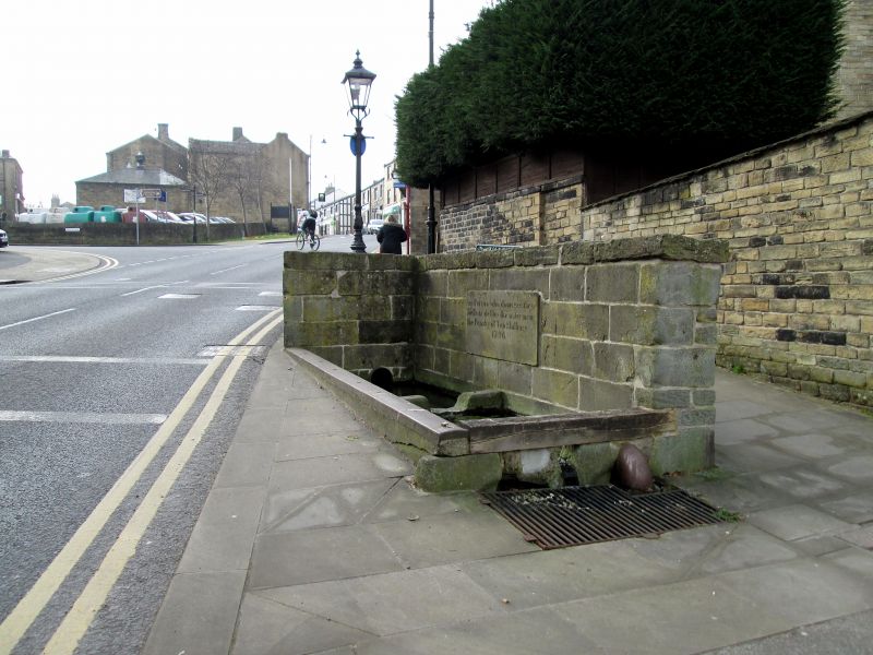
SE 1312 EASTGATE
9/84 (Honley)
16.1.67 Honley Wells
II
Two large stone troughs with deeply coursed stone wall to 2 sides. 1796 (dated).
Carved plaque reads:
Any Person who damages these
Wells or defiles the water incurs
the Penalty of Ten Shillings
1796
Carved into corner stone is inscription HT
1850
'The History of Honley', M A Jagger, 1914.
Listing NGR: SE1388212000
External links are from the relevant listing authority and, where applicable, Wikidata. Wikidata IDs may be related buildings as well as this specific building. If you want to add or update a link, you will need to do so by editing the Wikidata entry.


Other nearby listed buildings