Approximate Location Map
Large Map »
Latitude: 53.6517 / 53°39'5"N
Longitude: -1.8443 / 1°50'39"W
OS Eastings: 410389
OS Northings: 417250
OS Grid: SE103172
Mapcode National: GBR HVK6.JQ
Mapcode Global: WHCB0.MGZX
Plus Code: 9C5WM524+M7
Entry Name: 10-14, Lamb Hall Road
Listing Date: 29 September 1978
Grade: II
Source: Historic England
Source ID: 1134981
English Heritage Legacy ID: 340092
ID on this website: 101134981
Location: Salendine Nook, Kirklees, West Yorkshire, HD3
County: Kirklees
Electoral Ward/Division: Golcar
Parish: Non Civil Parish
Built-Up Area: Huddersfield
Traditional County: Yorkshire
Lieutenancy Area (Ceremonial County): West Yorkshire
Church of England Parish: Longwood St Mark the Evangelist
Church of England Diocese: Leeds
Tagged with: Building
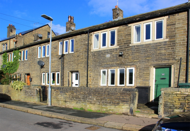
LAMB HALL ROAD
1.
5113
(North Side)
Longwood
Nos 10 to 14 (even)
SE 1017 26/764
II GV
2.
Early C19. Hammer-dressed stone. Pitched stone slate roof. 2 storeys. Six
3-light stone mullioned windows on 1st floor. Three 4-light stone mullioned
windows (No 10's has one mullion removed) on ground floor.
Listing NGR: SE1038917250
External links are from the relevant listing authority and, where applicable, Wikidata. Wikidata IDs may be related buildings as well as this specific building. If you want to add or update a link, you will need to do so by editing the Wikidata entry.
Other nearby listed buildings


