Approximate Location Map
Large Map »
Latitude: 51.5065 / 51°30'23"N
Longitude: -1.5258 / 1°31'33"W
OS Eastings: 433004
OS Northings: 178729
OS Grid: SU330787
Mapcode National: GBR 6Z0.K1P
Mapcode Global: VHC1D.HDPF
Plus Code: 9C3WGF4F+JM
Entry Name: 7, Mill Lane
Listing Date: 28 August 1981
Last Amended: 11 July 1983
Grade: II
Source: Historic England
Source ID: 1136350
English Heritage Legacy ID: 39457
ID on this website: 101136350
Location: Lambourn, West Berkshire, RG17
County: West Berkshire
Civil Parish: Lambourn
Built-Up Area: Lambourn
Traditional County: Berkshire
Lieutenancy Area (Ceremonial County): Berkshire
Church of England Parish: Lambourn
Church of England Diocese: Oxford
Tagged with: Building
SU 37NW LAMBOURN MILL LANE
6/10 No 7
(formerly listed
under Blind Lane)
28.8.81 II
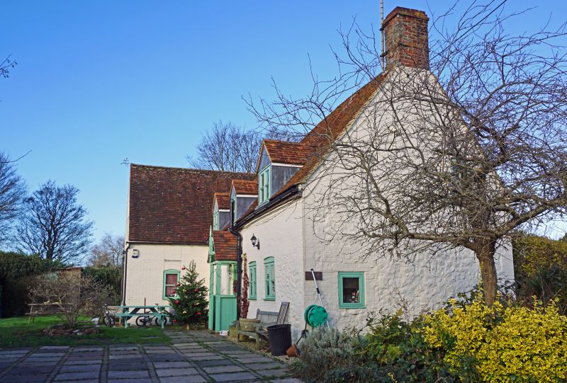
House. C17. 1½ storeys, sarsen with brick quoins and dressings, painted. Old tile
roof, flanking chimneys small amount of timber framing visible at rear. 3 square
headed dormers with vertical sliding sashes. 3 timber casements with cambered
heads. Door to left of centre under modern porch.
Listing NGR: SU3300478729
External links are from the relevant listing authority and, where applicable, Wikidata. Wikidata IDs may be related buildings as well as this specific building. If you want to add or update a link, you will need to do so by editing the Wikidata entry.


Other nearby listed buildings
