Approximate Location Map
Large Map »
Latitude: 54.323 / 54°19'22"N
Longitude: -2.7978 / 2°47'52"W
OS Eastings: 348207
OS Northings: 492226
OS Grid: SD482922
Mapcode National: GBR 8LXG.23
Mapcode Global: WH82W.0L0S
Plus Code: 9C6V86F2+5V
Entry Name: Toll Bar Cottage
Listing Date: 22 November 1983
Grade: II
Source: Historic England
Source ID: 1136950
English Heritage Legacy ID: 75315
ID on this website: 101136950
Location: Westmorland and Furness, Cumbria, LA8
County: Cumbria
District: South Lakeland
Civil Parish: Underbarrow and Bradleyfield
Traditional County: Westmorland
Lieutenancy Area (Ceremonial County): Cumbria
Church of England Parish: Underbarrow with Helsington
Church of England Diocese: Carlisle
Tagged with: Cottage
SD 49 SE UNDERBARROW AND
BRADLEYFIELD
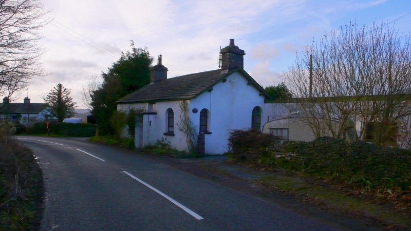
1/44 Toll Bar Cottage
II
Toll house, C18. Stone, rendered walls, slate roof, stone ridge. End chimney
stacks. Central doorway with stone slab porch (probably later addition). Round
headed window to either side of door with C20 glazing. C20 extension to right
hand side not included in listing.
Listing NGR: SD4820792226
External links are from the relevant listing authority and, where applicable, Wikidata. Wikidata IDs may be related buildings as well as this specific building. If you want to add or update a link, you will need to do so by editing the Wikidata entry.


Other nearby listed buildings
