Approximate Location Map
Large Map »
Latitude: 53.2158 / 53°12'56"N
Longitude: -2.0261 / 2°1'33"W
OS Eastings: 398356
OS Northings: 368749
OS Grid: SJ983687
Mapcode National: GBR 23B.JKL
Mapcode Global: WHBBX.VFDK
Plus Code: 9C5V6X8F+8H
Entry Name: The Old Post Office
Listing Date: 25 July 1952
Grade: II
Source: Historic England
Source ID: 1138899
English Heritage Legacy ID: 58103
ID on this website: 101138899
Location: Wildboarclough, Cheshire East, Cheshire, SK11
County: Cheshire East
Civil Parish: Macclesfield Forest and Wildboarclough
Traditional County: Cheshire
Lieutenancy Area (Ceremonial County): Cheshire
Church of England Parish: Wildboarclough St Saviour
Church of England Diocese: Chester
Tagged with: Post office
WILDBOARCLOUGH C.P.
SJ 96 NE
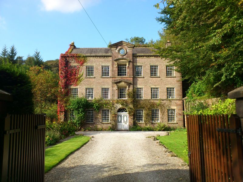
3/9 The Old Post Office.
25/7/1952
GV II
House, formerly post office and postmaster's house with village hall
on upper storey; originally offices of Crag Works, early C19, with
3-storey porch probably mid C19. Of coursed sandstone rubble with
ashlar dressings and Kerridge stone-slate roof with coped gables and
small gable chimneys. 3 storeys, 7 windows with central 3-storey
porch capped with an open Doric pediment. The arched doorway has
double doors with raised ellipse-on-cross upper panels surmounted by a
radial-bar fan. Segmental pedimented recessed fixed-light 25-pane
wooden windows to upper storeys above doorway. Other window to front
and rear are of cast iron with 35 panes (lower storey, front) and 30
panes and inset casements. Steep bank to right with external stone
steps and causeway giving access to upper storey (former loading door
blocked).
Interior 4-panel doors. Cased iron I-beams. Stone stairs in walled
well, the steps later cased in softwood.
The Crag Works, of which the Old Post Office is the only surviving
part, was built as a water-powered carpet works; it was built with
Crag Hall before 1819. (Brian S Beeken, Crag Works, Wildboarclough;
Greenwoods Map 1819; Bryants Map 1831; Tithe Map 1849).
Listing NGR: SJ9835668749
External links are from the relevant listing authority and, where applicable, Wikidata. Wikidata IDs may be related buildings as well as this specific building. If you want to add or update a link, you will need to do so by editing the Wikidata entry.


Other nearby listed buildings
