Latitude: 51.1287 / 51°7'43"N
Longitude: 1.308 / 1°18'28"E
OS Eastings: 631556
OS Northings: 141806
OS Grid: TR315418
Mapcode National: GBR X2Z.1KD
Mapcode Global: VHLHB.MWCM
Plus Code: 9F3348H5+F6
Entry Name: Royal Victoria Hospital (Block Dated 1849)
Listing Date: 17 December 1973
Grade: II
Source: Historic England
Source ID: 1139048
English Heritage Legacy ID: 177769
ID on this website: 101139048
Location: Dover, Kent, CT16
County: Kent
District: Dover
Town: Dover
Civil Parish: Dover
Built-Up Area: Dover
Traditional County: Kent
Lieutenancy Area (Ceremonial County): Kent
Tagged with: Hospital building
HIGH STREET 1. (North East Side) 1050 Royal Victoria Hospital (Block dated 1849) TR 3141 2/40
II
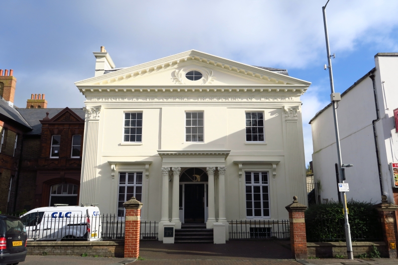
2. Dated 1849, but in character 30 years or so earlier. 2 storeys and basement with area stuccoed. Composite pilasters flank the front, Modillion cornice and a large pediment with a circular window in its tympanum. Architraves over ground floor windows supported on voluted consoles. 3 sashes with glazing bars intact on 1st floor. Porch up 5 steps with a pair of twin Composite columns. 6 panel moulded double door with a narrow light on either side of it and a large semi-circular fanlight. Area railings. Victorian additions to the North.
Listing NGR: TR3155641806
External links are from the relevant listing authority and, where applicable, Wikidata. Wikidata IDs may be related buildings as well as this specific building. If you want to add or update a link, you will need to do so by editing the Wikidata entry.


Other nearby listed buildings