Approximate Location Map
Large Map »
Latitude: 53.286 / 53°17'9"N
Longitude: -2.6251 / 2°37'30"W
OS Eastings: 358420
OS Northings: 376738
OS Grid: SJ584767
Mapcode National: GBR BZ3F.GS
Mapcode Global: WH993.NN4R
Plus Code: 9C5V79PF+9W
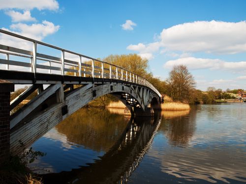
Entry Name: Horse Bridge over River 250 Metres South West of Dutton Lock
Listing Date: 4 May 1979
Grade: II
Source: Historic England
Source ID: 1139138
English Heritage Legacy ID: 57495
ID on this website: 101139138
Location: Cheshire West and Chester, Cheshire, WA4
County: Cheshire West and Chester
Civil Parish: Dutton
Traditional County: Cheshire
Lieutenancy Area (Ceremonial County): Cheshire
Church of England Parish: Weaverham St Mary the Virgin
Church of England Diocese: Chester
Tagged with: Footbridge
SJ 57 NE DUTTON C.P.
4/49 Horse Bridge over river
250 metres south west of
Dutton Lock
4/5/79
GV II
Footbridge 1915, timber, by A Saver, engineer to the Weaver Navigation
Trust. 2 long segmental arches of laminated timber carry slightly
arched footway on triangulated timber strutting. Plain post-and-rail
parapets. Concrete springers; brick abutments with weathered concrete
copings. An elegant structure in the functional waterways tradition;
built in 1915-1916, it is a very early surviving example of a pre-
stressed laminated timber structure, the arches having spans of 100 feet
7 inches and 101 feet 7 inches.
Working Drawings and coloured elevation dated 1915 at BWB Office,
Navigation Road, Northwich.
Listing NGR: SJ5842076738
External links are from the relevant listing authority and, where applicable, Wikidata. Wikidata IDs may be related buildings as well as this specific building. If you want to add or update a link, you will need to do so by editing the Wikidata entry.


Other nearby listed buildings
