Latitude: 54.5118 / 54°30'42"N
Longitude: -1.357 / 1°21'25"W
OS Eastings: 441729
OS Northings: 513132
OS Grid: NZ417131
Mapcode National: GBR LJZ8.0F
Mapcode Global: WHD74.4V2K
Plus Code: 9C6WGJ6V+P6
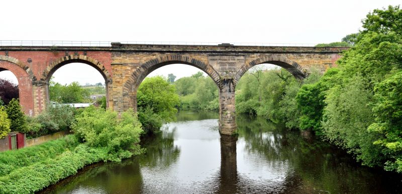
Entry Name: Yarm Viaduct
Listing Date: 23 June 1966
Last Amended: 21 June 1985
Grade: II
Source: Historic England
Source ID: 1139259
English Heritage Legacy ID: 59250
ID on this website: 101139259
Location: Yarm, Stockton-on-Tees, North Yorkshire, TS15
County: Stockton-on-Tees
Civil Parish: Yarm
Built-Up Area: Yarm
Traditional County: Yorkshire
Lieutenancy Area (Ceremonial County): North Yorkshire
Church of England Parish: Yarm St Mary Magdalene
Church of England Diocese: York
Tagged with: Railway viaduct
HZ 4113 SE EGGLESCLIFFE TANNER'S BANK (off)
NZ 4112 NE (South side)
35/681 Yarm Viaduct
37/681 (Formerly listed as
The Railway Viaduct)
23.6.66
II
On the common boundary of the Parishes of Egglescliffe and Yarm, and previously
listed on 23 June 1966 in the Parish of Yarm. See under River Tees and Valley in
the Parish of Yarm.
Listing NGR: NZ4172913132
External links are from the relevant listing authority and, where applicable, Wikidata. Wikidata IDs may be related buildings as well as this specific building. If you want to add or update a link, you will need to do so by editing the Wikidata entry.


Other nearby listed buildings