Approximate Location Map
Large Map »
Latitude: 54.5503 / 54°33'0"N
Longitude: -1.3758 / 1°22'32"W
OS Eastings: 440471
OS Northings: 517401
OS Grid: NZ404174
Mapcode National: GBR LHTT.YM
Mapcode Global: WHD6X.VW1L
Plus Code: 9C6WHJ2F+4M
Entry Name: Home Farmhouse
Listing Date: 21 June 1985
Grade: II
Source: Historic England
Source ID: 1139262
English Heritage Legacy ID: 59260
ID on this website: 101139262
Location: Elton, Stockton-on-Tees, North Yorkshire, TS21
County: Stockton-on-Tees
Civil Parish: Elton
Traditional County: Durham
Lieutenancy Area (Ceremonial County): County Durham
Church of England Parish: Elton
Church of England Diocese: Durham
Tagged with: Farmhouse
NZ 41 NW ELTON DARLINGTON ROAD
(North side)
10/497
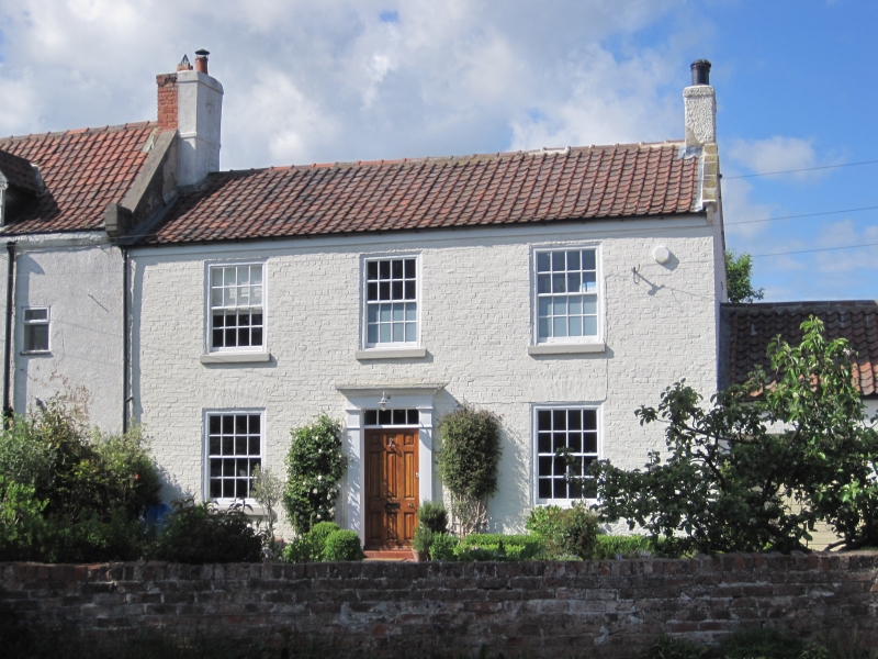
Home Farmhouse
II
Early-mid C19. Painted brick. Pantiled roof with end chimneys, stone copings
and kneelers. Two storeys, three windows. Gauged flat brick arches to sash
windows with glazing bars, stone cills. Modern central door, oblong fanlight.
Listing NGR: NZ4047117401
External links are from the relevant listing authority and, where applicable, Wikidata. Wikidata IDs may be related buildings as well as this specific building. If you want to add or update a link, you will need to do so by editing the Wikidata entry.


Other nearby listed buildings
