Approximate Location Map
Large Map »
Latitude: 50.1178 / 50°7'4"N
Longitude: -5.5362 / 5°32'10"W
OS Eastings: 147307
OS Northings: 30181
OS Grid: SW473301
Mapcode National: GBR DXQC.LWM
Mapcode Global: VH12Z.092J
Plus Code: 9C2P4F97+4G
Entry Name: Egyptian House
Listing Date: 29 July 1950
Grade: I
Source: Historic England
Source ID: 1143147
English Heritage Legacy ID: 69438
Also known as: Egyptian House, Penzance
ID on this website: 101143147
Location: Penzance, Cornwall, TR18
County: Cornwall
Civil Parish: Penzance
Built-Up Area: Penzance
Traditional County: Cornwall
Lieutenancy Area (Ceremonial County): Cornwall
Church of England Parish: Penzance St Mary the Virgin with St Paul
Church of England Diocese: Truro
Tagged with: House
1.
1498 PENZANCE
CHAPEL STREET
(South West Side)
Nos 6 and 7
(Egyptian House)
SW 4730 5/20 29.7.50.
I GV
2.
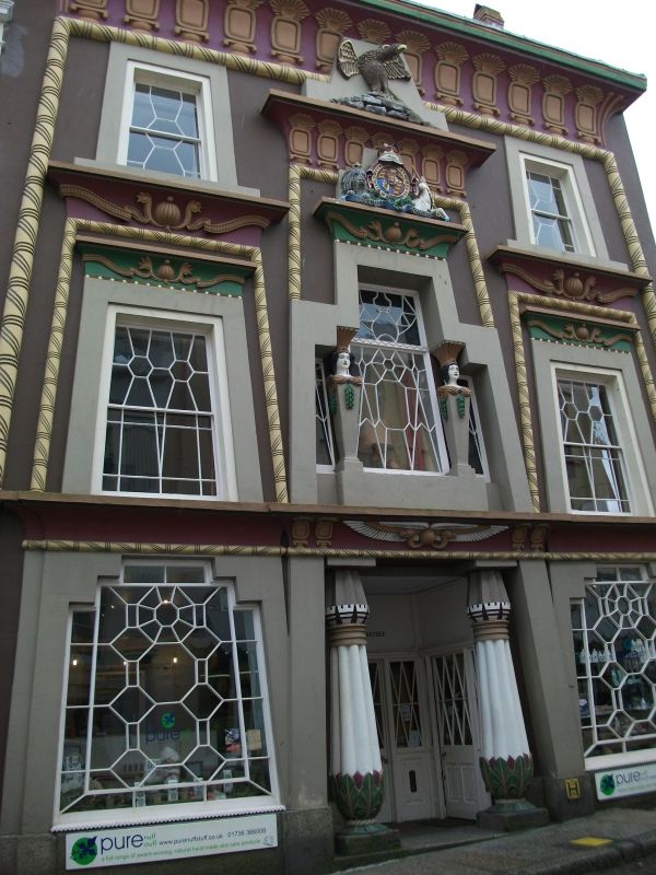
Early C19 stucco Egyptian extravagance. 3 storeys. 3 windows Battered half
round corded pilasters, windows and glazing bars. Lotus bud columns flanking
entrance. Coved cornices above windows. 2 obelisk caryatids. A coat of arms
crowned by an eagle. Heavy coved crowning cornice.
Nos 5 to 11 (consec) form a group.
Listing NGR: SW4730730181
External links are from the relevant listing authority and, where applicable, Wikidata. Wikidata IDs may be related buildings as well as this specific building. If you want to add or update a link, you will need to do so by editing the Wikidata entry.


Other nearby listed buildings
