Approximate Location Map
Large Map »
Latitude: 54.7779 / 54°46'40"N
Longitude: -2.9872 / 2°59'14"W
OS Eastings: 336595
OS Northings: 543000
OS Grid: NY365430
Mapcode National: GBR 7FL6.21
Mapcode Global: WH80N.25SJ
Plus Code: 9C6VQ2H7+54
Entry Name: Bell Bridge
Listing Date: 3 January 1986
Grade: II
Source: Historic England
Source ID: 1144429
English Heritage Legacy ID: 72459
ID on this website: 101144429
Location: Cumberland, Cumbria, CA5
County: Cumbria
District: Allerdale
Civil Parish: Sebergham
Traditional County: Cumberland
Lieutenancy Area (Ceremonial County): Cumbria
Church of England Parish: Castle Sowerby St Kentigern
Church of England Diocese: Carlisle
Tagged with: Bridge
NY 34 SE SEBERGHAM Bellbridge
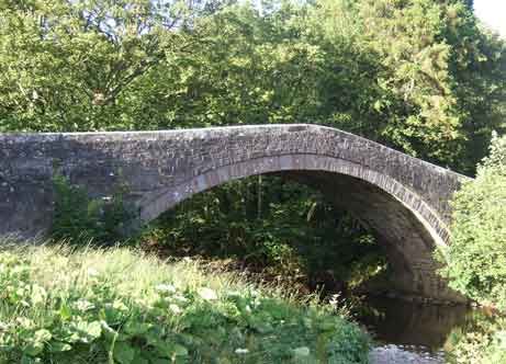
9/151 Bell Bridge
II
Roadbridge. 1772 with C19 repairs. Coursed red sandstone. Hump-back bridge of
single-span segmental arch under solid parapet with chamfered coping. Named
after the Bell family of Bell-bridge Farmhouse and replaced C17 bridge washed
away in a flood of 1771. See Parson and White's Directory of Cumberland &
Westmorland, 1829, p380.
Listing NGR: NY3659543000
External links are from the relevant listing authority and, where applicable, Wikidata. Wikidata IDs may be related buildings as well as this specific building. If you want to add or update a link, you will need to do so by editing the Wikidata entry.


Other nearby listed buildings
