Latitude: 54.6678 / 54°40'3"N
Longitude: -2.7508 / 2°45'2"W
OS Eastings: 351672
OS Northings: 530558
OS Grid: NY516305
Mapcode National: GBR 9G7G.8J
Mapcode Global: WH814.QX9Z
Plus Code: 9C6VM69X+4M
Entry Name: 19 and 20, Arthur Street
Listing Date: 9 February 1983
Grade: II
Source: Historic England
Source ID: 1145140
English Heritage Legacy ID: 72765
ID on this website: 101145140
Location: Scaws, Westmorland and Furness, Cumbria, CA11
County: Cumbria
District: Eden
Civil Parish: Penrith
Built-Up Area: Penrith
Traditional County: Cumberland
Lieutenancy Area (Ceremonial County): Cumbria
Church of England Parish: Penrith St Andrew
Church of England Diocese: Carlisle
Tagged with: Building
1.
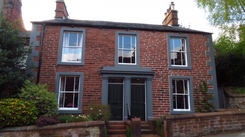
5165 ARTHUR STREET
(north-west side)
Nos 19 and 20
NY 5130 1/14
II GV
2.
Mid C19 red sandstone with quoins, 2 storeys. Paired doorway in centre with
two panelled doors and small rectangular fanlights, pilasters and cornice.
Two 6-paned sash windows on ground floor and 3 above.
Listing NGR: NY5167230558
External links are from the relevant listing authority and, where applicable, Wikidata. Wikidata IDs may be related buildings as well as this specific building. If you want to add or update a link, you will need to do so by editing the Wikidata entry.


Other nearby listed buildings