Approximate Location Map
Large Map »
Latitude: 54.6073 / 54°36'26"N
Longitude: -2.74 / 2°44'24"W
OS Eastings: 352298
OS Northings: 523825
OS Grid: NY522238
Mapcode National: GBR 9H95.L5
Mapcode Global: WH81J.WGD9
Plus Code: 9C6VJ745+WX
Entry Name: Stable Block East of Lowther Castle
Listing Date: 6 February 1968
Grade: II*
Source: Historic England
Source ID: 1145326
English Heritage Legacy ID: 74346
ID on this website: 101145326
Location: Newtown, Westmorland and Furness, Cumbria, CA10
County: Cumbria
District: Eden
Civil Parish: Lowther
Traditional County: Westmorland
Lieutenancy Area (Ceremonial County): Cumbria
Church of England Parish: Askham with Lowther
Church of England Diocese: Carlisle
Tagged with: Stable
NY 52 SW LOWTHER LOWTHER
12/138 Stable block east of
Lowther Castle
6.2.68
GV II*
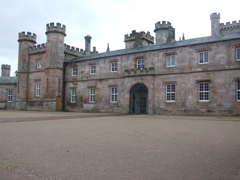
Stables and Coach house adjoining Lowther Castle. 1806-9 by Sir Robert Smirke
for 1st Earl of Lonsdale. Calciferous sandstone ashlar with string courses and
battlemented parapets. Graduated greenslate roofs, partly hipped. Buildings on
3 sides of courtyard. Rear 2-storey, 7-bay coach house has ground-floor
segmental arches under 2-light stone-mullioned windows with hoodmoulds.
Battlemented parapet rises in centre with clock face and Lowther arms. Right
single-storey, 4-bay quadrant link and left similar 2-storey link, have central
segmental arch and sash windows under hoodmoulds. Left 2-storey, 9-bay stables
has 7 recessed bays with flanking rectangular battlemented turrets. Central
segmental arch and sash windows under hoodmoulds. Turrets have rounded-arched
windows. Right domestic/stable range is similar to the left range opposite, but
with angle turrets on projecting bays, that to right forming part of the return
wall of the castle facade. The Household Accounts of the Earl of Lonsdale in
the County Record Office, Carlisle, record payment on 30 June 1806, to William
Bayles & Co, of £10. 2s. 6d. "for removing 405 yards of earth previous to laying
foundations for new stables, coach houses, etc". Graded for group value with
Lowther Castle.
Listing NGR: NY5229823825
External links are from the relevant listing authority and, where applicable, Wikidata. Wikidata IDs may be related buildings as well as this specific building. If you want to add or update a link, you will need to do so by editing the Wikidata entry.


Other nearby listed buildings
