Approximate Location Map
Large Map »
Latitude: 54.3309 / 54°19'51"N
Longitude: -2.7406 / 2°44'26"W
OS Eastings: 351935
OS Northings: 493066
OS Grid: SD519930
Mapcode National: GBR 9L9C.G8
Mapcode Global: WH82W.WD4Q
Plus Code: 9C6V87J5+9Q
Entry Name: Castle Dairy, 26 Wildman Street
Listing Date: 24 April 1951
Grade: I
Source: Historic England
Source ID: 1145642
English Heritage Legacy ID: 75521
ID on this website: 101145642
Location: Kendal, Westmorland and Furness, Cumbria, LA9
County: Cumbria
District: South Lakeland
Civil Parish: Kendal
Built-Up Area: Kendal
Traditional County: Westmorland
Lieutenancy Area (Ceremonial County): Cumbria
Church of England Parish: Kendal St George
Church of England Diocese: Carlisle
Tagged with: Architectural structure
This list entry was subject to a Minor Amendment on 29 July 2021 to update the name and address and to reformat the text to current standards
SD 5193 SE
5/176
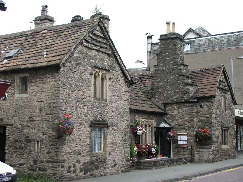
KENDAL
WILDMAN STREET (North side)
No 26 (Castle Dairy)
24-4-51
I
Farmhouse; the name implies an association with Kendal Castle but 'Dairy' may be a corruption of 'Dowry'. Now a restaurant. Probably C14; extensively remodelled c1560 for Anthony Garnett (numerous dated features have survived). Later additions and alterations. Coursed rubble with quoins. Graduated stone-flag roofs; stone chimneys (corbelled to west wing and projecting to east wing). Central Hall with two-storey cross-wing to either end.
For detailed description (including exceptionally well-preserved interior) see R.C.H.M. Westmorland (1936), with the following amendments: multi-light windows, to Hall front and to west wing first floor, were renewed in 1983/84 (all in facsimile except for heads carved on label-stops to Hall window). On the interior, two more original doorways (with pointed heads) have been opened up on the left-hand side of the cross-passage; the ground floor, east wing, fireplace and some of the original windows have also been unblocked. The extension to the rear of the west wing has been demolished.
Listing NGR: SD5193593066
External links are from the relevant listing authority and, where applicable, Wikidata. Wikidata IDs may be related buildings as well as this specific building. If you want to add or update a link, you will need to do so by editing the Wikidata entry.


Other nearby listed buildings
