Latitude: 50.6065 / 50°36'23"N
Longitude: -2.4535 / 2°27'12"W
OS Eastings: 368002
OS Northings: 78630
OS Grid: SY680786
Mapcode National: GBR PY.DPHX
Mapcode Global: FRA 57RG.FZP
Plus Code: 9C2VJG4W+JH
Entry Name: Harbour House
Listing Date: 18 June 1970
Grade: II
Source: Historic England
Source ID: 1148080
English Heritage Legacy ID: 467979
ID on this website: 101148080
Location: Weymouth, Dorset, DT4
County: Dorset
Electoral Ward/Division: Weymouth East
Parish: Weymouth
Built-Up Area: Weymouth
Traditional County: Dorset
Lieutenancy Area (Ceremonial County): Dorset
Church of England Parish: Weymouth Holy Trinity
Church of England Diocese: Salisbury
Tagged with: House
WEYMOUTH
SY6878NW TRINITY ROAD 873-1/24/369 (South side) 18/06/70 No.1 Harbour House
GV II
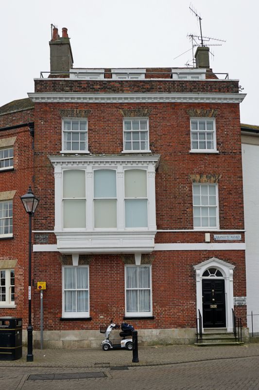
House in row. Late C18 front with later C19 modifications, late C17 or early C18 back range. Flemish bond brickwork, squared and coursed Portland stone, tile and slate roofs. PLAN: a parallel-range building, with an early range behind a rebuilt front block. EXTERIOR: the front is in 3 storeys with attic, 3 windows; 2-light flat-roofed dormers above 9-pane sashes, above a large square flat-roofed 1:3:1-light Victorian oriel with modillion cornice, and a 12-pane sash. Ground floor has two 4-pane sashes. The sashes are all to brick voussoirs in painted reveals and to stone sills; the ground floor sashes also have a stone keystone. To the right, in a pilaster doorcase with open pediment is a 6-panel door under radial fanlight, on 4 nosed steps with simple iron handrail. The steps rise to the height of an ashlar plinth. A plain string at the level of the bottom of the oriel, and a thin sill band. The blocking and parapet return at the ends, above a stone modillion cornice. Large stacks at the gables. The rear range, in stone with slate roof, is also in 3 storeys with attic; the stone section with swept-down roof, is set forward from one bay, left, in brickwork. There are 2 close-set early 8-pane sash dormers above two 12-pane sashes to flush moulded boxes, brick voussoirs and stone sills, at 3 levels. The set-back section has 6- over 12-pane sashes in reveals. Both parts have a brick saw-tooth dentil eaves. INTERIOR not inspected, but likely to be of interest. This is the grandest of the line of properties facing N across the Quay, at the point where Trinity Road and Trinity Street converge.
Listing NGR: SY6800278630
External links are from the relevant listing authority and, where applicable, Wikidata. Wikidata IDs may be related buildings as well as this specific building. If you want to add or update a link, you will need to do so by editing the Wikidata entry.


Other nearby listed buildings