Approximate Location Map
Large Map »
Latitude: 54.1686 / 54°10'7"N
Longitude: -0.6755 / 0°40'31"W
OS Eastings: 486567
OS Northings: 475570
OS Grid: SE865755
Mapcode National: GBR RNQ7.KF
Mapcode Global: WHGCG.LHK3
Plus Code: 9C6X589F+FR
Entry Name: Pump House Approximately 80 Metres East of Scampston Hall and Attached Walls Sunk in Ground on South Side
Listing Date: 14 December 1987
Grade: II
Source: Historic England
Source ID: 1149666
English Heritage Legacy ID: 329392
ID on this website: 101149666
Location: Scampston, North Yorkshire, YO17
County: North Yorkshire
District: Ryedale
Civil Parish: Scampston
Traditional County: Yorkshire
Lieutenancy Area (Ceremonial County): North Yorkshire
Church of England Parish: Scampston with Wintringham
Church of England Diocese: York
Tagged with: Pump
SE 87 NE
4/52
SCAMPSTON
SCAMPSTON HALL ESTATE
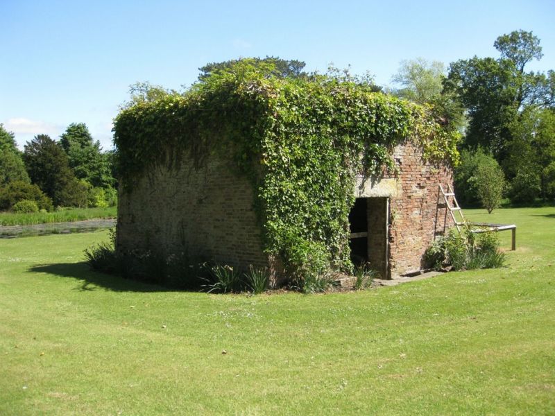
Pump House approximately 80 metres east of Scampston Hall and attached walls sunk in ground on south side.
GV
II
Pump house. 1778 on datestone. Orange-red brick in English garden wall
bond on tooled sandstone base; stone coping. Exterior wall of orange-red
brick. Square on plan. Battered east side has low segment-arched opening
and blocked roundel above. South side has segment arch between shaped
abutments over channel running through building. On west side is wide
doorway beneath heavy lintel. Date panel sunk in raised surround on north
side, hidden by ivy. Interior: partly sunken floor forms wheel pit for
undershot wheel. Massive tunnel-vaulted roof. Channel bringing water from
the adjacent lake, together with a sluice, may be seen to south-east.
Water, collected in the small pond on south side was controlled by a sluice
within the pumphouse, from where it was channelled through the building,
flowing out through a tailrace on the north side. Included for industrial-
historic interest.
Listing NGR: SE8656775570
External links are from the relevant listing authority and, where applicable, Wikidata. Wikidata IDs may be related buildings as well as this specific building. If you want to add or update a link, you will need to do so by editing the Wikidata entry.


Other nearby listed buildings
