Approximate Location Map
Large Map »
Latitude: 54.0083 / 54°0'29"N
Longitude: -1.4703 / 1°28'13"W
OS Eastings: 434813
OS Northings: 457050
OS Grid: SE348570
Mapcode National: GBR LQ52.HW
Mapcode Global: WHD9L.DJ30
Plus Code: 9C6W2G5H+8V
Entry Name: Gallon Steps with 2 Lamp Posts and Walls, Linking Waterside and Kirkgate
Listing Date: 12 December 1985
Grade: II
Source: Historic England
Source ID: 1149863
English Heritage Legacy ID: 330872
ID on this website: 101149863
Location: Knaresborough, North Yorkshire, HG5
County: North Yorkshire
District: Harrogate
Civil Parish: Knaresborough
Built-Up Area: Knaresborough
Traditional County: Yorkshire
Lieutenancy Area (Ceremonial County): North Yorkshire
Church of England Parish: Knaresborough
Church of England Diocese: Leeds
Tagged with: Architectural structure
SE 3457
6/202
KNARESBOROUGH
WATERSIDE (north side, off)
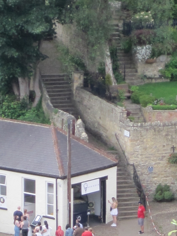
Gallon steps, with two lamp posts and walls, linking Waterside and Kirkgate.
GV
II
Steps, flanking walls and lamp posts. Brick, gritstone, cobbles and cast iron. Early C19.
Steps: seven flights, approximately two metres wide. Gritstone slabs over stone and brick core. Some C20 restoration. Cobble platforms between flights.
Walls: coursed gritstone with pointed coping, approximately one metre high on outside. Inner wall is part rubble and part coursed gritstone.
Lamp posts: fluted columns, lanterns restored c1980.
The steps appear to have been named after Richard Gallon, gent, who kept the Nidd pavilion in 1822. They are also recorded as Factory Steps, and the 1851 Ordnance Survey map shows a linen factory built against the cliff face about halfway along their line. The lamp posts were probably first erected when the town was lit by gas in 1824.
W A Atkinson, Knaresborough and its Manor Houses, 1924, p 26. Ordnance Survey, Map of Knaresborough, 5 feet to 1 mile, 1851. White's Directory of Yorkshire, 1822, p 225.
Listing NGR: SE3481357050
External links are from the relevant listing authority and, where applicable, Wikidata. Wikidata IDs may be related buildings as well as this specific building. If you want to add or update a link, you will need to do so by editing the Wikidata entry.


Other nearby listed buildings
