Latitude: 53.5626 / 53°33'45"N
Longitude: -1.1989 / 1°11'55"W
OS Eastings: 453159
OS Northings: 407635
OS Grid: SE531076
Mapcode National: GBR NW27.7M
Mapcode Global: WHDCV.KQ95
Plus Code: 9C5WHR72+3C
Entry Name: Church of All Saints
Listing Date: 23 March 1988
Grade: II
Source: Historic England
Source ID: 1151514
English Heritage Legacy ID: 334868
Also known as: All Saints' Church, Woodlands
ID on this website: 101151514
Location: All Saints Church, Woodlands, Doncaster, South Yorkshire, DN6
County: Doncaster
Electoral Ward/Division: Adwick le Street & Carcroft
Parish: Non Civil Parish
Built-Up Area: Adwick le Street
Traditional County: Yorkshire
Lieutenancy Area (Ceremonial County): South Yorkshire
Church of England Parish: Woodlands All Saints
Church of England Diocese: Sheffield
Tagged with: Church building
ADWICK-LE-STREET CENTRAL AVENUE SE 50 NW (west side), Woodlands
11/4 Church of All Saints
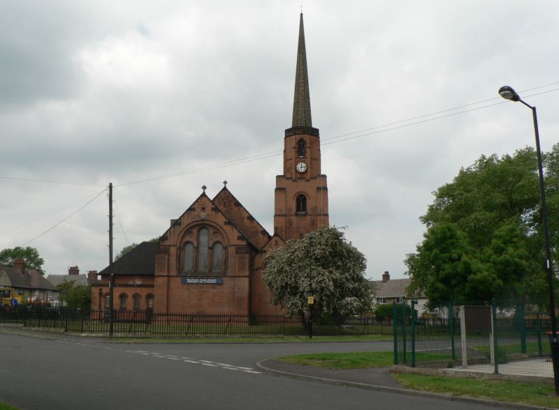
GV II Church. 1911-13, By W. H. Wood for patron Charles Thellusson of Brodsworth Hall. Red brick in English bond with some ashlar sandstone dressings, tiled roofs. Orientated north-west/south-east, ritual orientation used here. 4-bay aisled nave with entrance beneath tower at north-west corner; 2-bay chancel with north chapel and south organ chamber and vestry. In Romanesque style: round-arched openings with pelleted hoodmoulds. Tower: 4 + 2 stages with spire; chamfered brick plinth bands, clasping buttresses (that to south- west incorporating stair turret); north doorway with shafts (1 missing) to round arch over double doors with keyed lintel; string course beneath 2nd stage; offset beneath upper stages with 2-light louvred belfry openings in hooded recesses; offset beneath embattled parapet behind which rises an octagonal, 2-stage turret with diagonal buttresses and clocks beneath pointed 2-light louvred openings on the cardinal faces; turret parapet around recessed needle spire. Nave: brick plinth, buttresses between bays. North side has door and window to easternmost bay and 2 windows to other bays, lean-to roof; groups of 3 clerestorey windows to each bay; gable coping with apex crosses. South side similar, doorway to bay 1. West end has 2 windows in a projection beneath 3-light window with shafts; circular gable window. Chancel : lower. Separately-roofed north chapel with east buttress and 3 windows to north; circular ashlar window to east. East end of chancel, set forward, has clasping buttesses and foundation stone dated 1911 below window of 3 stepped lights divided by shafts and with roundels beneath round arch. Hipped-roof south organ chamber with lower flat-roofed vestry on east; chancel above has lateral stack on left of 2 windows and east gable copings with cross.
Interior: arcades have octagonal and cylindrical piers and 3-order round arches in brick with continuous pelleted hoodmoulds. Chancel arch has shafts in the jambs; large round arch into organ chamber, 2 smaller arches into north chapel on cylindrical pier with carved capital. Fittings; no pews; traceried roof screen with crucifixion. Plaque on south-west pier of nave records Charles Thellussun's gift of the church to the parish upon its consecration in 1913.
The church forms a focal point of the Woodlands colliery village laid out and designed by Percy B, Houfton of Chesterfield for the Brodsworth Colliery Company during 1907-1908. Houfton had previously designed colliery estates at Creswell and Bolsover in Derbyshire and with the sinking of the Brodsworth Colliery in 1907 was commissioned to lay out housing along the enlightened lines of the newly emerging Garden Cities movement. Houfton applied the Arts and Crafts style to the estate houses which were built in 2 phases; the style borrows from that of C. F. A, Voysey who, in 1904/5, had designed some colliery housing at Whitwood, nr. Castleford, Leeds (Davey, plate 87). Phase one of Woodlands took place around a parkland site and its irregular low density plan retaining mature trees has most appeal although most of its housing has undergone alteration (see items listed under 'The Park'). Rapid expansion of the colliery necessitated that the 2nd, much larger, phase be hurried (to the dissatisfaction of Houfton himself) and the resultant scheme is one of greater density around a horseshoe crescent with central and radiating avenues. Several blocks of little-altered housing survive to illustrate the nature of the original scheme (see under Central Avenue, Great North Road, Green Lane, Harold Avenue, Quarry Lane, The Crescent and West Avenue). Primary and Secondary schools and the present Health Centre are the most notable public buildings erected on the estate (see under Central Avenue, Chadwick Road and The Park). The estate received critical acclaim at the time and its importance has been outlined more recently by Martin Gaskell (1979).
P. Davey, Arts an Crafts Architecture, 1980, p 94.
M. Gaskell, 'Model Industrial Villages in S. Yorkshire/N, Derbyshire and the Early Town Planning Movement, Town Planninq Review, vol 50, No. 4, Oct 1979, pp437-458,
Listing NGR: SE5315907635
External links are from the relevant listing authority and, where applicable, Wikidata. Wikidata IDs may be related buildings as well as this specific building. If you want to add or update a link, you will need to do so by editing the Wikidata entry.


Other nearby listed buildings