Approximate Location Map
Large Map »
Latitude: 53.5111 / 53°30'39"N
Longitude: -1.1898 / 1°11'23"W
OS Eastings: 453824
OS Northings: 401904
OS Grid: SE538019
Mapcode National: GBR NW4V.63
Mapcode Global: WHDD7.P0MN
Plus Code: 9C5WGR66+C3
Entry Name: Village Pump Immediately to East of Number 41
Listing Date: 11 April 1986
Grade: II
Source: Historic England
Source ID: 1151604
English Heritage Legacy ID: 334568
ID on this website: 101151604
Location: Sprotbrough, Doncaster, South Yorkshire, DN5
County: Doncaster
Civil Parish: Sprotbrough and Cusworth
Built-Up Area: Sprotbrough
Traditional County: Yorkshire
Lieutenancy Area (Ceremonial County): South Yorkshire
Church of England Parish: Sprotbrough St Mary the Virgin
Church of England Diocese: Sheffield
Tagged with: Well
SE50SW
7/147
SPROTBROUGH
MAIN STREET
(south side)
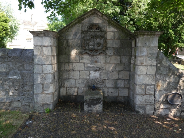
Village pump immediately to east of No 41
II
Village pump. Early C19. Deeply-coursed, squared limestone; cast-iron pump.
Remains of pump shaft with cuboidal stone bucket platform set in gabled recess with
projecting side piers. Copley arms carved on sandstone slab set above pump;
moulded cornice to piers and gable.
Listing NGR: SE5382401904
External links are from the relevant listing authority and, where applicable, Wikidata. Wikidata IDs may be related buildings as well as this specific building. If you want to add or update a link, you will need to do so by editing the Wikidata entry.


Other nearby listed buildings
