Latitude: 51.941 / 51°56'27"N
Longitude: -2.3362 / 2°20'10"W
OS Eastings: 376982
OS Northings: 226994
OS Grid: SO769269
Mapcode National: GBR 0HR.B4V
Mapcode Global: VH93X.GG8X
Plus Code: 9C3VWMR7+9G
Entry Name: Mill
Listing Date: 18 October 1985
Grade: II
Source: Historic England
Source ID: 1153410
English Heritage Legacy ID: 125809
ID on this website: 101153410
Location: Forest of Dean, Gloucestershire, GL18
County: Gloucestershire
District: Forest of Dean
Civil Parish: Upleadon
Traditional County: Gloucestershire
Lieutenancy Area (Ceremonial County): Gloucestershire
Church of England Parish: Upleadon St Mary the Virgin
Church of England Diocese: Gloucester
Tagged with: Mill
SO 72 NE UPLEADON FORGE LANE
(north side)
4/273 Mill
II
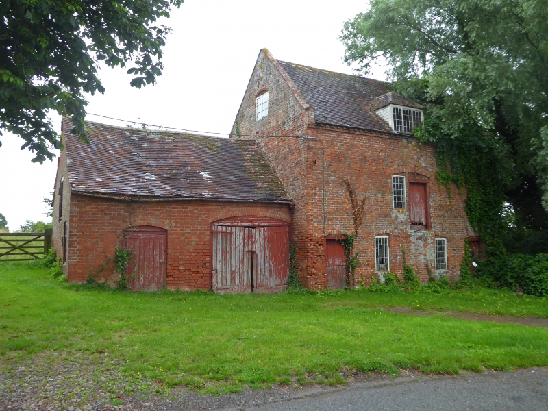
Mill. Early C19, late C19 extension. Flemish bond brick, tiled
roof. Three-bay mill, 2½ storeys: 2-bay, single-storey
extension. Facade to road: boarded stable door to left original
section, cambered brick arch: 20-pane window, with centre-pivot
opening section replaced with single-pane of glass, in left half of
original window, right bricked up, all under cambered brick arch.
To right similar window and blocking, mirrored: boarded door under
cambered brick arch. Set back beyond gable short brick wall,
formerly carrying roof, shields undershot wheel. First floor
central opening, cambered brick-on-end arch, 20-pane window on
left, boarded door on right. Slightly-projecting eaves course of
bricks: central hipped dormer, 3-light window, 12 panes per light.
Parapet gable with saddleback brick copings. Two-light casement
in gable, left return, cambered brick arch. To left single-storey
wing, double boarded doors on right under cambered brick arch;
ordinary boarded door on left, eaves as main block. Internally,
stone-paved ground floor: vertical drive and cogwheels survive.
Top floor reached by ladder: grain bins with raised walkway in
centre at tie beam level: queen-strut trusses.
Listing NGR: SO7698226994
External links are from the relevant listing authority and, where applicable, Wikidata. Wikidata IDs may be related buildings as well as this specific building. If you want to add or update a link, you will need to do so by editing the Wikidata entry.


Other nearby listed buildings