Latitude: 51.8338 / 51°50'1"N
Longitude: -2.2841 / 2°17'2"W
OS Eastings: 380517
OS Northings: 215062
OS Grid: SO805150
Mapcode National: GBR 0JZ.Z7N
Mapcode Global: VH94J.C5BJ
Plus Code: 9C3VRPM8+G8
Entry Name: Bridge Keeper's House to West of Rea Bridge
Listing Date: 30 September 1985
Grade: II
Source: Historic England
Source ID: 1154698
English Heritage Legacy ID: 131821
ID on this website: 101154698
Location: Quedgeley, Gloucester, Gloucestershire, GL2
County: Gloucestershire
District: Gloucester
Civil Parish: Quedgeley
Built-Up Area: Gloucester
Traditional County: Gloucestershire
Lieutenancy Area (Ceremonial County): Gloucestershire
Church of England Parish: Quedgeley
Church of England Diocese: Gloucester
Tagged with: House
SO 81 NW QUEDGELEY ELMORE LANE (south side) 2/159 Bridge keeper's house to west of Rea Bridge
II
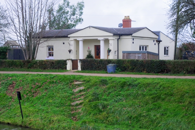
Bridge keeper's house. c1830 with C20 addition; by Robert Mylne, engineer to the Gloucester and Berkeley Ship Canal. Stucco; brick chimney; asbestos cement slate roof. Greek revival; single-storey; portico facing canal. Gable ends to original house with low-pitched pediment over continuous entablature. Front: portico off-centre to right with fluted Greek Doric order columns on circular bases: distyle in antis, with engaged flanking walls each with small square window; central doorway with original architraves and C20 glazed door; single C19 four-pane sash to left. South end: Cl9 four-pane sash; pediment filled and rendered. North end: C20 casement with glazed C20 door to left. Back: pediment on axis with portico; brick chimney; large C20 flat-roofed addition is not of special interest. An example of one of the 2 standard designs for bridge keeper's houses on the canal (c.f. that at Sellars Bridge, Hardwicke CP, q.v.), attributed to Mylne but executed after his death. (D. Verey, Gloucestershire: The Vale and the Forest of Dean, 1976.)
Listing NGR: SO8051715062
External links are from the relevant listing authority and, where applicable, Wikidata. Wikidata IDs may be related buildings as well as this specific building. If you want to add or update a link, you will need to do so by editing the Wikidata entry.


Other nearby listed buildings