Approximate Location Map
Large Map »
Latitude: 55.6417 / 55°38'30"N
Longitude: -1.989 / 1°59'20"W
OS Eastings: 400792
OS Northings: 638688
OS Grid: NU007386
Mapcode National: GBR G3K6.6F
Mapcode Global: WH9Z4.FG39
Plus Code: 9C7WJ2R6+MC
Entry Name: Farmbuildimgs C 20 Yards West of Lowick High Steads Farmhouse
Listing Date: 15 May 1986
Grade: II
Source: Historic England
Source ID: 1155924
English Heritage Legacy ID: 237789
ID on this website: 101155924
Location: Northumberland, TD15
County: Northumberland
Civil Parish: Lowick
Built-Up Area: Lowick
Traditional County: Northumberland
Lieutenancy Area (Ceremonial County): Northumberland
Church of England Parish: Lowick and Kyloe St John the Baptist
Church of England Diocese: Newcastle
Tagged with: Agricultural structure
NU 03 NW LOWICK B 6525
(East side, off)
6/81
Farmbuildings c.20 yards
west of Lowick High
Steads Farmhouse
GV II
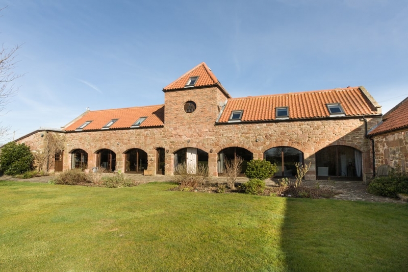
Shelter sheds, dovecote and byre. Mid C18. Random rubble and brick with pantiled
and corrugated iron roof. 2 ranges at right-angles.
Long range to rear has 3 segmental arches left and 3 right of central square
dovecote tower which has lower segmental arch on ground floor. Upper parts of tower
brick. Round entry to dovecote has wooden screen with alighting ledges and 6 holes.
Pyramidal pantiled roof to tower. Gabled corrugated iron roofs to shelter sheds
though roof marks of original very steeply-pitched roof visible on sides of tower.
Projecting on right a single-storey byre with on plank door. Steeply-pitched gabled
roof with pantiles and thin raised coping.
Listing NGR: NU0079238688
External links are from the relevant listing authority and, where applicable, Wikidata. Wikidata IDs may be related buildings as well as this specific building. If you want to add or update a link, you will need to do so by editing the Wikidata entry.


Other nearby listed buildings
