Latitude: 54.4179 / 54°25'4"N
Longitude: -1.6922 / 1°41'31"W
OS Eastings: 420070
OS Northings: 502533
OS Grid: NZ200025
Mapcode National: GBR JKMC.F3
Mapcode Global: WHC6D.Z7B1
Plus Code: 9C6WC895+44
Entry Name: Hall Farmhouse
Listing Date: 6 November 1986
Grade: II
Source: Historic England
Source ID: 1157763
English Heritage Legacy ID: 322195
ID on this website: 101157763
Location: Skeeby, North Yorkshire, DL10
County: North Yorkshire
District: Richmondshire
Civil Parish: Skeeby
Traditional County: Yorkshire
Lieutenancy Area (Ceremonial County): North Yorkshire
Church of England Parish: Easby with Brompton on Swale and Bolton on Swale
Church of England Diocese: Leeds
Tagged with: Farmhouse
This list entry was subject to a Minor Amendment on 9 December 2025 to reformat the text to current standards
NZ 20 SW
5/128
SKEEBY
RICHMOND ROAD (south side)
Hall Farmhouse
GV
II
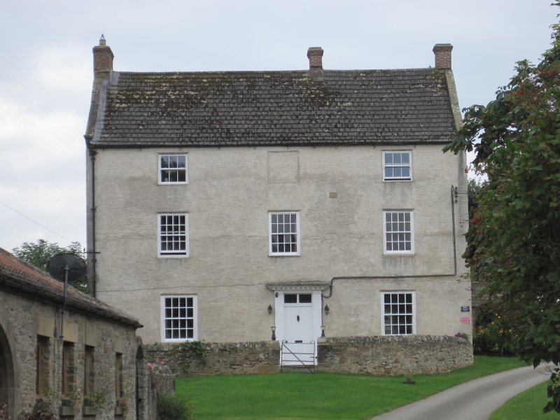
Farmhouse. Dated 1747. Roughcast rubble, C20 concrete interlocking tile roof. Three storeys, three bays, double-depth plan.
North elevation: central leaved two-panel doors below two-pane overlight in mid C19 modillion-cornice doorcase. Windows have brick surrounds larger than present openings and flush wooden architraves. Ground and first floors: sixteen-pane sash windows. Second floor: six-pane sash windows, the central one blind and painted to match. To its right, a plaque inscribed "I M 1747". Shaped kneelers, ashlar coping. M-section roof. Corniced brick stacks at ends and between second and third bays.
Rear: tall landing window, partly-blocked to form fixed-light twelve-pane window. Right bay of two storeys, with first-floor double four-pane sash window in C18 architrave.
Interior: good staircase, rising full height of building, with column-on-vase turned balusters.
Listing NGR: NZ2007002533
This list entry was subject to a Minor Amendment on 9 December 2025 to reformat the text to current standards
NZ 20 SW
5/128
SKEEBY
RICHMOND ROAD (south side)
Hall Farmhouse
GV
II
Farmhouse. Dated 1747. Roughcast rubble, C20 concrete interlocking tile roof. Three storeys, three bays, double-depth plan.
North elevation: central leaved two-panel doors below two-pane overlight in mid C19 modillion-cornice doorcase. Windows have brick surrounds larger than present openings and flush wooden architraves. Ground and first floors: sixteen-pane sash windows. Second floor: six-pane sash windows, the central one blind and painted to match. To its right, a plaque inscribed "I M 1747". Shaped kneelers, ashlar coping. M-section roof. Corniced brick stacks at ends and between second and third bays.
Rear: tall landing window, partly-blocked to form fixed-light twelve-pane window. Right bay of two storeys, with first-floor double four-pane sash window in C18 architrave.
Interior: good staircase, rising full height of building, with column-on-vase turned balusters.
Listing NGR: NZ2007002533
External links are from the relevant listing authority and, where applicable, Wikidata. Wikidata IDs may be related buildings as well as this specific building. If you want to add or update a link, you will need to do so by editing the Wikidata entry.


Other nearby listed buildings