Approximate Location Map
Large Map »
Latitude: 54.4556 / 54°27'20"N
Longitude: -2.1603 / 2°9'37"W
OS Eastings: 389703
OS Northings: 506698
OS Grid: NY897066
Mapcode National: GBR FJCX.3K
Mapcode Global: WHB4V.S8GM
Plus Code: 9C6VFR4Q+6V
Entry Name: Tan Hill Inn
Listing Date: 17 June 1976
Last Amended: 17 June 1986
Grade: II
Source: Historic England
Source ID: 1159627
English Heritage Legacy ID: 111170
Also known as: Tan Hill Inn, Tan Hill, Richmond
ID on this website: 101159627
Location: North Yorkshire, DL11
County: North Yorkshire
District: Richmondshire
Civil Parish: Muker
Traditional County: Yorkshire
Lieutenancy Area (Ceremonial County): North Yorkshire
Tagged with: Inn Pub Eating and lodging
BOWES LONG CAUSEWAY
NY 80 NE 897067 (North side)
22/12 Tan Hill Inn
II
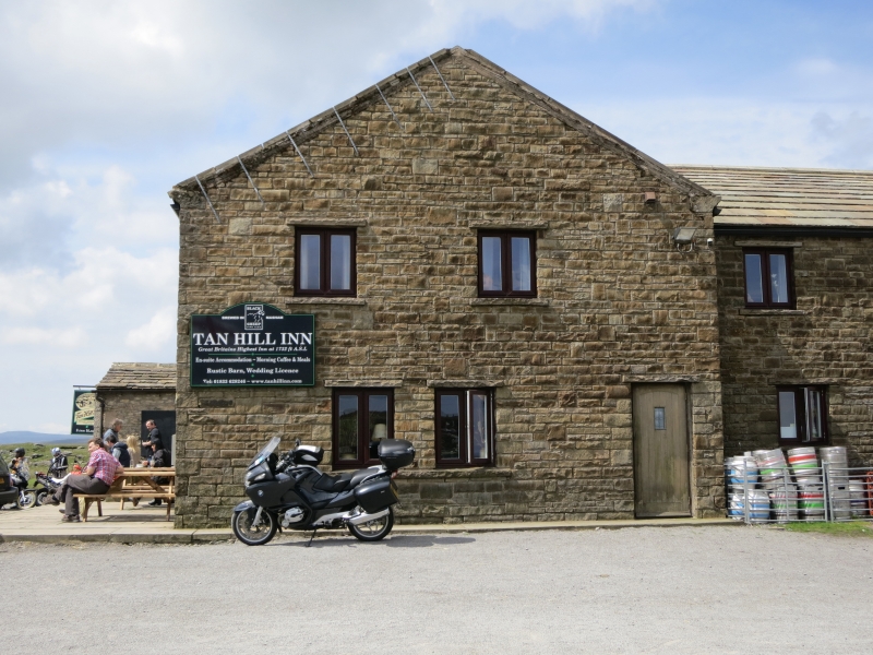
Public house. Early-mid C18 with mid C19 and late C20 alterations. Squared
rubble. Imitation stone-flagged roof and stone chimney stacks; porch has
sandstone-flagged roof.
2 storeys, 5 bays with irregular flush quoins. Solid gabled porch in fourth
bay, with replaced door in right return. Blocked doorway in second bay. 3
late C20 ground-floor casements in tooled flush surrounds. First floor: 3
identical windows; blank fourth bay; small blocked window in left bay. Roof
with broken shaped kneelers. Rebuilt end stacks.
Interior: ground-floor right front room has a large stone fireplace with
corniced lintel on corbelled jambs.
C20 additions to right return and rear are not of special interest.
At 1732 feet above sea level this is said to be the highest public house in
Britain.
Listing NGR: NY8970306698
External links are from the relevant listing authority and, where applicable, Wikidata. Wikidata IDs may be related buildings as well as this specific building. If you want to add or update a link, you will need to do so by editing the Wikidata entry.


Other nearby listed buildings
