Approximate Location Map
Large Map »
Latitude: 52.2152 / 52°12'54"N
Longitude: -0.5863 / 0°35'10"W
OS Eastings: 496684
OS Northings: 258387
OS Grid: SP966583
Mapcode National: GBR DZQ.2M4
Mapcode Global: VHFPS.SLF5
Plus Code: 9C4X6C87+3F
Entry Name: 50-52, Church Lane
Listing Date: 27 August 1987
Grade: II
Source: Historic England
Source ID: 1159969
English Heritage Legacy ID: 37063
ID on this website: 101159969
Location: Odell, Bedford, Bedfordshire, MK43
County: Bedford
Civil Parish: Odell
Traditional County: Bedfordshire
Lieutenancy Area (Ceremonial County): Bedfordshire
Church of England Parish: Odell
Church of England Diocese: St.Albans
Tagged with: Building Thatched cottage
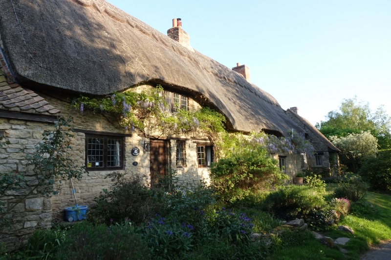
ODELL CHURCH LANE
SP 9658
19/293 Nos. 50 - 52 (even)
-
- II
Terrace of cottages with datestone 1705 on south gable apex. Coursed
limestone rubble, thatched roofs. Two storeys. Stone coped gable end to
south. Three stacks. Road elevation has several casements with leaded
lights. Single storey pantiled outhouse on northern gable end. Modern stone
and tiled extension on south end, forward of building line.
Listing NGR: SP9668458387
External links are from the relevant listing authority and, where applicable, Wikidata. Wikidata IDs may be related buildings as well as this specific building. If you want to add or update a link, you will need to do so by editing the Wikidata entry.


Other nearby listed buildings
