Latitude: 54.5344 / 54°32'3"N
Longitude: -1.0233 / 1°1'23"W
OS Eastings: 463296
OS Northings: 515892
OS Grid: NZ632158
Mapcode National: GBR PJ90.7B
Mapcode Global: WHF8F.79Y7
Plus Code: 9C6WGXMG+PM
Entry Name: Little Waterfall Farmhouse and Adjoining Outbuilding
Listing Date: 25 April 1984
Grade: II
Source: Historic England
Source ID: 1159981
English Heritage Legacy ID: 60087
ID on this website: 101159981
Location: Redcar and Cleveland, North Yorkshire, TS14
County: Redcar and Cleveland
Civil Parish: Guisborough
Traditional County: Yorkshire
Lieutenancy Area (Ceremonial County): North Yorkshire
Church of England Parish: Guisborough St Nicholas
Church of England Diocese: York
Tagged with: Farmhouse
NZ61NW GUISBOROUGH WHITBY ROAD (OFF SOUTH SIDE)
3/230 Little Waterfall Farmhouse and adjoining outbuilding.
II
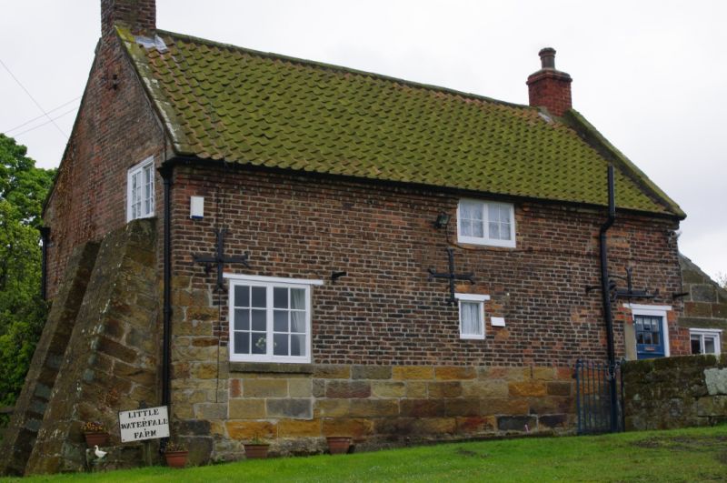
House. Late C18 adaptation/reconstruction of earlier (C17) building. Lower parts (most of ground floor) squared random rubble sandstone and dressed sandstone; upper part brick. Clay pantile roof; stone ridge and gable copings; stacks at gables; plain stepped brick corbelling at eaves. 1½ storeys. 3 cross tie-plates between floors on N. and S. sides. 2 bays. Yorkshire sashes with glazing bars to ground floor; mid C20 casements with glazing bars, in original openings, to first floor. Keyed lintels to ground floor windows. East gable supported by pair of raked dressed sandstone buttresses. 2 chamfered basement window openings in E. wall. One blocked window opening to basement, RHS of front (S.) elevation. Listing includes the single-storey lean-to outbuilding adjoining W.side. Late C18. Dressed sandstone, brick and clay pantiles.
Listing NGR: NZ6329615892
External links are from the relevant listing authority and, where applicable, Wikidata. Wikidata IDs may be related buildings as well as this specific building. If you want to add or update a link, you will need to do so by editing the Wikidata entry.


Other nearby listed buildings