Approximate Location Map
Large Map »
Latitude: 51.8175 / 51°49'3"N
Longitude: -0.8147 / 0°48'52"W
OS Eastings: 481799
OS Northings: 213876
OS Grid: SP817138
Mapcode National: GBR D2X.4T8
Mapcode Global: VHDV4.TLN1
Plus Code: 9C3XR59P+24
Entry Name: Water Pump
Listing Date: 5 February 1973
Grade: II
Source: Historic England
Source ID: 1160342
English Heritage Legacy ID: 41899
ID on this website: 101160342
Location: Aylesbury, Buckinghamshire, HP20
County: Buckinghamshire
Civil Parish: Aylesbury
Built-Up Area: Aylesbury
Traditional County: Buckinghamshire
Lieutenancy Area (Ceremonial County): Buckinghamshire
Church of England Parish: Aylesbury
Church of England Diocese: Oxford
Tagged with: Well
1,
799 PEBBLE LANE
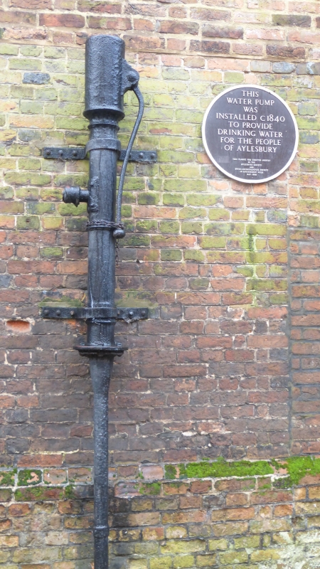
Water Pump
SP 8113 NE 1/265
II
2.
Circa 1840, the only remaining exmple of the public pumps which supplied
Aylesbury with drinking water. Cast iron with handle for hand pumping,
shaft about 10 feet high. Secured to wall of lane by metal brackets.
Listing NGR: SP8179913876
External links are from the relevant listing authority and, where applicable, Wikidata. Wikidata IDs may be related buildings as well as this specific building. If you want to add or update a link, you will need to do so by editing the Wikidata entry.


Other nearby listed buildings
