Approximate Location Map
Large Map »
Latitude: 53.391 / 53°23'27"N
Longitude: -2.5807 / 2°34'50"W
OS Eastings: 361478
OS Northings: 388396
OS Grid: SJ614883
Mapcode National: GBR BYF7.24
Mapcode Global: WH98R.B1B7
Plus Code: 9C5V9CR9+9P
Entry Name: Ring O' Bells Public House
Listing Date: 4 April 1975
Grade: II
Source: Historic England
Source ID: 1161372
English Heritage Legacy ID: 58782
ID on this website: 101161372
Location: Howley, Warrington, Cheshire, WA1
County: Warrington
Electoral Ward/Division: Fairfield and Howley
Parish: Non Civil Parish
Built-Up Area: Warrington
Traditional County: Lancashire
Lieutenancy Area (Ceremonial County): Cheshire
Church of England Parish: Warrington St Elphin
Church of England Diocese: Liverpool
Tagged with: Pub
CHURCH STREET
1,
5150 (South Side)
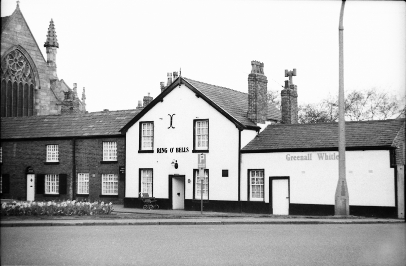
Ring o' Bells Public House
SJ 6188 1/55
II GV
2.
C18 inn, 2 storeys, brick, with wide gabled front to Church approach, with centre
boarded door, 2 12-paned sash windows on each floor, and bargeboards. Low single
storeyed wing to right, extending to Church Street, with low door and a 12-paned
sash.
Ring o' Bells Public House Nos l3l to 137 (odd) Church of St Elphin cobbled
approach and Gateway form a group with Nos 142 to 160 (even).
Listing NGR: SJ6146988396
External links are from the relevant listing authority and, where applicable, Wikidata. Wikidata IDs may be related buildings as well as this specific building. If you want to add or update a link, you will need to do so by editing the Wikidata entry.


Other nearby listed buildings
