Latitude: 52.1677 / 52°10'3"N
Longitude: -0.5997 / 0°35'58"W
OS Eastings: 495868
OS Northings: 253083
OS Grid: SP958530
Mapcode National: GBR F08.55V
Mapcode Global: VHFPZ.KSB3
Plus Code: 9C4X5C92+34
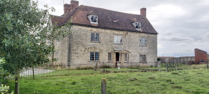
Entry Name: Great Oaks Farmhouse
Listing Date: 27 August 1987
Grade: II
Source: Historic England
Source ID: 1161388
English Heritage Legacy ID: 37303
ID on this website: 101161388
Location: Bedford, Bedfordshire, MK43
County: Bedford
Civil Parish: Turvey
Traditional County: Bedfordshire
Lieutenancy Area (Ceremonial County): Bedfordshire
Church of England Parish: Turvey
Church of England Diocese: St.Albans
Tagged with: Farmhouse
TURVEY BEDFORD ROAD SP 95 SE (N. Side)
8/558 Great Oaks Farmhouse - - II
C18 house extended C19. Coursed limestone rubble. Old clay tile roof. Original house of 3 bays. In C19, 2 bays were added to N.W. to form an L-plan and the roof hipped around the S.W. corner. Also gabled wing added in the angle of the L. Two storeys and attics. S. entrance front has two hipped dormers with 2-light casements with glazing bars. First floor has three 2- light casements with glazing bars unoer timber lintels. Ground floor has four casements with glazing bars, two to either side of central door. Those immediately flanking the doorway are single light. The door is in panelled reveals with a pedimented canopy on slim Ionic columns. W. elevation of return wing also now of 3 bays. Central slightly projecting gabled section with small attic casement window. First floor has 1:1:1 2-light casement windows with glazing bars; the right hand one in the original house under a timber lintel. Ground floor has central 2-light casement flanked by French doors, again right hand opening with timber lintel.
Listing NGR: SP9586853083
External links are from the relevant listing authority and, where applicable, Wikidata. Wikidata IDs may be related buildings as well as this specific building. If you want to add or update a link, you will need to do so by editing the Wikidata entry.


Other nearby listed buildings