Latitude: 53.6916 / 53°41'29"N
Longitude: -1.0281 / 1°1'41"W
OS Eastings: 464273
OS Northings: 422124
OS Grid: SE642221
Mapcode National: GBR PT8R.6D
Mapcode Global: WHFDH.5GPS
Plus Code: 9C5WMXRC+JP
Entry Name: The Manor House
Listing Date: 23 April 1952
Grade: II
Source: Historic England
Source ID: 1162291
English Heritage Legacy ID: 164941
ID on this website: 101162291
Location: Snaith, East Riding of Yorkshire, DN14
County: East Riding of Yorkshire
Civil Parish: Snaith and Cowick
Built-Up Area: Snaith
Traditional County: Yorkshire
Lieutenancy Area (Ceremonial County): East Riding of Yorkshire
Church of England Parish: Great Snaith
Church of England Diocese: Sheffield
Tagged with: House
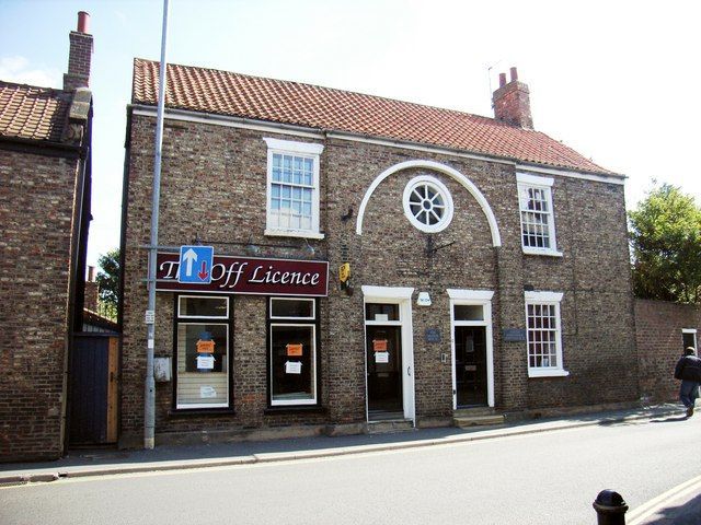
SNAITH AND COWICK SELBY ROAD SE 6422 (east side) 12/80 No 15/17 (The Manor House) 23.4.52 GV II House, now house and shop. c1800 with later alterations and rear addition. Grey brick in English bond; pantile roof. 2-room central entrance-hall plan with single-room wing to rear. 2 storeys, 3 bays. Stucco plinth. Central bay breaks forward with full-height round-arched panel containing pair of entrances: steps to C20 panelled door to right and half-glazed door to left, beneath plain overlights in reveals with painted brick flat arches. Pair of plate-glass shop windows with blind boxes to left beneath frieze. Original slightly-recessed unequal 20-pane sash to right with sill and painted brick flat arch. First floor: similar 20-pane sashes to side bays, central oculus with radial glazing bars in painted surround beneath painted brick arch. Plain C20 wooden eaves board. End stack to right. Interior: moulded cornice to ground floor left, fielded-panel doors; not fully investigated.
Listing NGR: SE6427322124
External links are from the relevant listing authority and, where applicable, Wikidata. Wikidata IDs may be related buildings as well as this specific building. If you want to add or update a link, you will need to do so by editing the Wikidata entry.


Other nearby listed buildings