Latitude: 53.5545 / 53°33'16"N
Longitude: -2.374 / 2°22'26"W
OS Eastings: 375320
OS Northings: 406498
OS Grid: SD753064
Mapcode National: GBR CWVB.TJ
Mapcode Global: WH97W.HXRD
Plus Code: 9C5VHJ3G+RC
Entry Name: Manchester Bolton and Bury Canal Milestone at 8 miles from Manchester
Listing Date: 19 August 1986
Last Amended: 31 October 2025
Grade: II
Source: Historic England
Source ID: 1162509
English Heritage Legacy ID: 210534
ID on this website: 101162509
Location: Nob End, Bolton, Greater Manchester, BL3
County: Bolton
Electoral Ward/Division: Little Lever and Darcy Lever
Parish: Non Civil Parish
Built-Up Area: Little Lever
Traditional County: Lancashire
Lieutenancy Area (Ceremonial County): Greater Manchester
Church of England Parish: Little Lever St Matthew
Church of England Diocese: Manchester
Tagged with: Milestone Architectural structure
A canal milestone of 1797, repositioned around 1890, for the Manchester, Bolton and Bury Canal. These stones marked the quarter-mile distances along the canal, which served many closely-spaced collieries.
A canal milestone of 1797, repositioned around 1890, for the Manchester, Bolton and Bury Canal.
MATERIALS: buff sandstone.
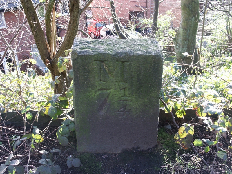
DESCRIPTION: the post stands around half a metre high and is set into the ground to the south of the towpath. It is rectangular in cross-section, with a flat top. The front (north) face is dressed, but the other faces rough-hewn. The front is inscribed ‘M/ 8’ (the distance from Manchester) in deeply-incised, serifed lettering.
The milestone at Prestolee Locks was originally erected in 1797, and installed in its current location just after 1890. The Manchester, Bolton and Bury Canal was authorised by Parliament in 1791 and opened to both of its destinations by 1797. It comprised a level summit canal extending to Bolton and Bury, and a branch descending 54m from Nob End (in the middle of this level) to Salford. The canal was connected to the River Irwell in 1808, and then across the Irwell to the Bridgewater Canal in 1838, and to the Rochdale Canal via the Manchester and Salford Junction Canal in 1839. This was principally a coal canal, and the frequency of collieries along it drove the requirement for distance posts to be sited every quarter of a mile, to allow accurate charging of tolls.
The Ordnance Survey (OS) 1:10.560 map of 1850 (surveyed between 1844 and 1846) marks a milestone showing a distance of 8 miles from Manchester on each of the Bolton and Bury branches of the canal. These were respectively just to the west and east of the Prestolee Locks which formed the junction of the three branches of the canal. Both are thought to have stood on the north bank of the canal. This stone is thought to have been the one originally on the Bolton branch. By 1890 when the OS 1:2,500 map of 1893 was surveyed, the Bolton branch stone remained where it had been marked in 1844 (in the angle of a sharp northward bend immediately to the west of the locks). The Bury branch stone is not marked on the 1890 survey. By 1909 however, the 1:2,500 OS map marks a stone where this one now stands, but no longer marks a stone on the Bolton branch.
Around 1890, several of the canal’s milestones were moved slightly closer to Salford, and from the north/east bank to the south/west bank. The new, more accurate 8-mile mark lay just to the east of the locks, and it is thought that the stone formerly on the Bolton branch was relocated around 180m east, to its current position. This post is therefore now one of a larger surviving complete sequence of 16 mileposts. The sequence of eight stones, spanning from the 7-mile marker on the Salford branch up to 8 3/4 miles on the Bolton branch (including this stone) was listed in 1986. The additional sequence extends by another eight stones to the 10-mile stone on the Bury branch. There is also a shorter sequence half a mile further north, from 10 3/4 to 11 3/4 miles on the Bury branch, which is missing the stone at 11 1/2 miles.
A major breach of the canal just east of this stone in 1936 cut the Bury branch off from Bolton and Salford, but this branch continued to be used for local traffic until 1966, and (in 2025) several sections are still in water. The entire canal was officially closed in 1961.
The Manchester Bolton and Bury Canal Milestone At 8 Miles From Manchester, a canal milestone of 1797 repositioned around 1890, is listed at Grade II for the following principal reasons:
Architectural interest:
* as a lettered milestone in its historic position it is a good example of historic canal furniture and illustrates the commercial operation of the canal.
External links are from the relevant listing authority and, where applicable, Wikidata. Wikidata IDs may be related buildings as well as this specific building. If you want to add or update a link, you will need to do so by editing the Wikidata entry.


Other nearby listed buildings