Latitude: 50.5477 / 50°32'51"N
Longitude: -4.1467 / 4°8'48"W
OS Eastings: 248003
OS Northings: 74190
OS Grid: SX480741
Mapcode National: GBR NW.GW49
Mapcode Global: FRA 276M.89X
Plus Code: 9C2QGVX3+38
Entry Name: Canal Bridge
Listing Date: 20 December 1983
Grade: II
Source: Historic England
Source ID: 1162940
English Heritage Legacy ID: 93419
ID on this website: 101162940
Location: Tavistock, West Devon, PL19
County: Devon
District: West Devon
Civil Parish: Tavistock
Built-Up Area: Tavistock
Traditional County: Devon
Lieutenancy Area (Ceremonial County): Devon
Tagged with: Bridge
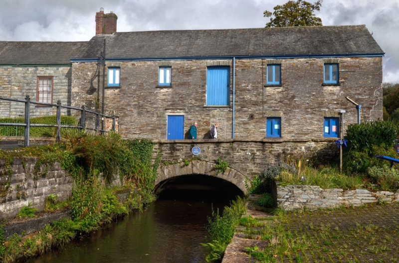
1.
5185 CANAL ROAD
(south west side)
Canal Bridge
SX 4774 3/38
SX 4874 4/38
II GV
2.
Circa 1817. Stone rubble bridge visible on south-west side of Canal Road only.
Cambered arch with rusticated voussoirs and keystone. Parapet. Included as part of
the industrial history of Tavistock.
Listing NGR: SX4800374190
External links are from the relevant listing authority and, where applicable, Wikidata. Wikidata IDs may be related buildings as well as this specific building. If you want to add or update a link, you will need to do so by editing the Wikidata entry.


Other nearby listed buildings