Approximate Location Map
Large Map »
Latitude: 52.3531 / 52°21'11"N
Longitude: -2.0807 / 2°4'50"W
OS Eastings: 394597
OS Northings: 272787
OS Grid: SO945727
Mapcode National: GBR 2FQ.GRC
Mapcode Global: VH923.W3CX
Plus Code: 9C4V9W39+6P
Entry Name: Worms Ash Farmhouse
Listing Date: 1 November 1972
Grade: II
Source: Historic England
Source ID: 1166660
English Heritage Legacy ID: 155686
ID on this website: 101166660
Location: Worms Ash, Bromsgrove, Worcestershire, B61
County: Worcestershire
District: Bromsgrove
Civil Parish: Dodford with Grafton
Traditional County: Worcestershire
Lieutenancy Area (Ceremonial County): Worcestershire
Church of England Parish: Dodford Holy Trinity
Church of England Diocese: Worcester
Tagged with: Farmhouse
COCKSHUT LANE
1.
909
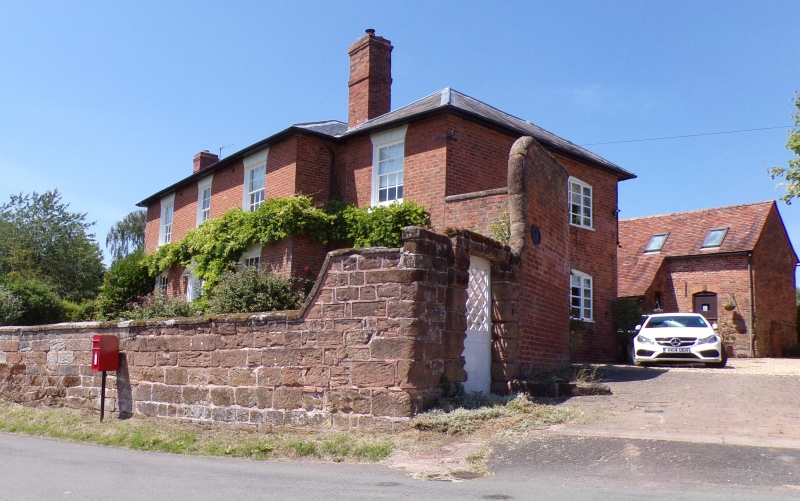
WORMS ASH
Worms Ash
Farmhouse
SO 97 SW 7/128
II
2.
Late C18. Red brick. 2 storeys. 3 windows, barred sashes, rusticated stucco
lintels with key-blocks. Central door, fielded panels, rectangular fanlight,
pilastered case, open oediment. Slate hipped roof.
Listing NGR: SO9459772787
External links are from the relevant listing authority and, where applicable, Wikidata. Wikidata IDs may be related buildings as well as this specific building. If you want to add or update a link, you will need to do so by editing the Wikidata entry.


Other nearby listed buildings
