Latitude: 53.785 / 53°47'5"N
Longitude: -1.0658 / 1°3'56"W
OS Eastings: 461648
OS Northings: 432479
OS Grid: SE616324
Mapcode National: GBR PS0N.1X
Mapcode Global: WHFD2.L4P5
Plus Code: 9C5WQWMM+XM
Entry Name: 34 and 36 Ousegate
Listing Date: 14 November 1980
Last Amended: 31 October 2024
Grade: II
Source: Historic England
Source ID: 1167535
English Heritage Legacy ID: 325815
ID on this website: 101167535
Location: Selby, North Yorkshire, YO8
County: North Yorkshire
District: Selby
Civil Parish: Selby
Built-Up Area: Selby
Traditional County: Yorkshire
Lieutenancy Area (Ceremonial County): North Yorkshire
Church of England Parish: Selby St Mary and St Germain
Church of England Diocese: York
Tagged with: Building
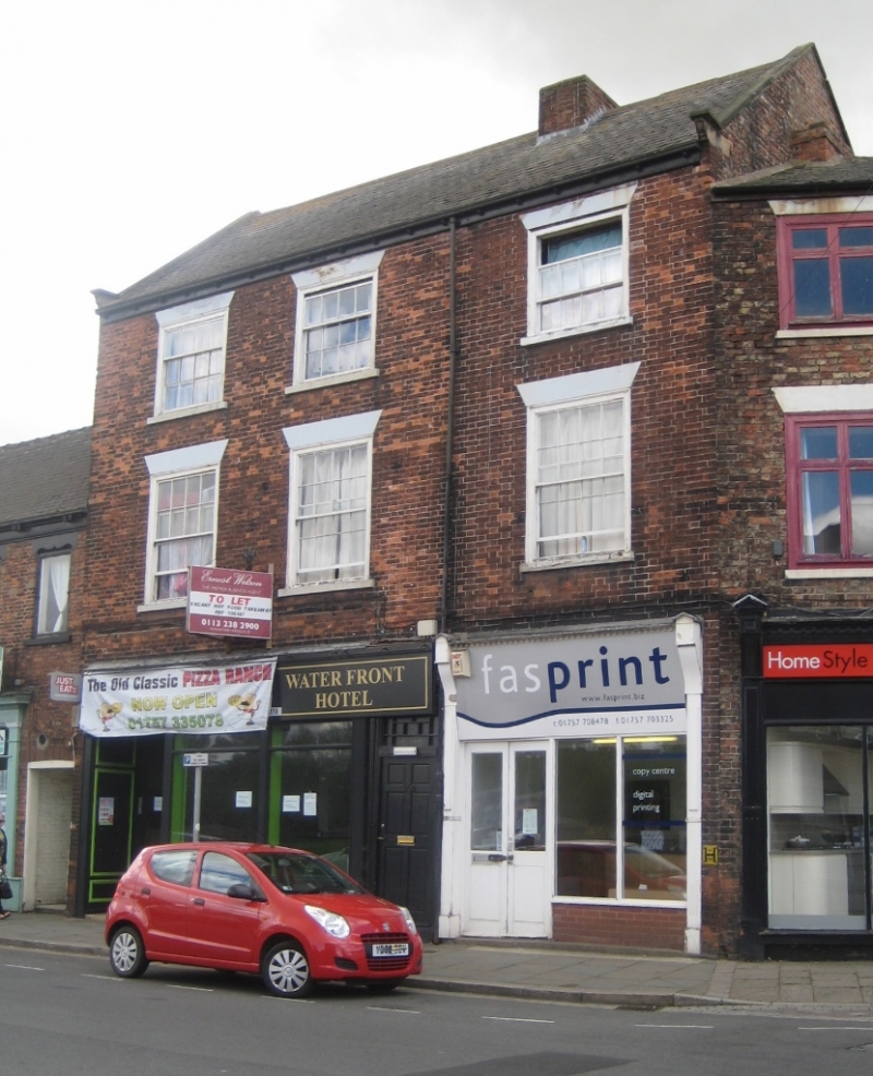
Pair of mid-C19 commercial properties with accommodation above and each with a rear range, altered in the C20 and C21.
A pair of mid-C19 commercial properties with accommodation above and each with a rear range, altered C20 and C21.
MATERIALS: hand-made red bricks, slate roof to front range, orange clay tiles to rear ranges.
PLAN: front range aligned north-west to south-east, with a central passage and two, two-storey rear ranges around 15m long.
EXTERIOR: the front facade is of three storeys and three bays, in Flemish bond brickwork, with number 36 occupying the two bays to the left. The ground floor of number 36 has a reproduction late-C19 shopfront with two windows and a recessed doorway to the left. Number 34 has a modern panelled double door and two plate glass shop windows with a brick stall riser. A passageway closed by a six-panel door with a multi-pane rectangular fanlight, is situated between the two shops. The first floor is lit by three 16-pane unhorned flush-framed sash windows with exposed sash boxes, painted wedge lintels, and projecting sills. The second floor has similar four-over-eight sashes. The roof is clad in Welsh slate, with coped gables and shaped kneelers. A truncated brick ridge stack is offset to the right. The ogee gutters and downpipes are cast-iron, and supported by a bracketed fascia board.
Selby as a settlement dates to the Anglo-Saxon period, when it was known as Seletun (old Scandinavian for ‘sallow tree settlement’) and was referred to by the Anglo-Saxon Chronicle of AD 779. A charter of about 1030 called it Seleby and about 1050 it was Selbi. King Henry I was born in Selby in 1068 and, a year later, Benedict, a French monk from Auxerre, obtained permission from King William to establish an Abbey. The Market Place has existed since the early C14. By the C15, Selby had developed thriving trade links along the East Coast and with the Low Countries. Selby Abbey succumbed to dissolution in 1539, and the core of the building became the parish church in 1618.
Selby’s commercial importance grew dramatically following the opening of the Selby Canal in 1778, becoming a notable inland port; however, after the building of Goole Docks in 1826, it suffered a very rapid decline. The town’s fortunes recovered in 1834, with the opening of the Leeds and Selby Railway, and by the early C20, witnessed a growth in several industries served by the railways and river traffic, including flour milling, malting, oilseed milling and cattle feed production. In 1983, coal production commenced from the Selby Coalfield. Shipbuilding ended ten years later, and coal mining ceased in 2004. Since then, there has been a gradual reduction in the traditional industries, although some remain.
The name Ousegate may have a Viking origin, as the suffix ‘gate’ is derived from the old Norse word ‘gatta’ meaning street. Ousegate is the historic riverfront street of Selby and remained an important area of commercial activity well into the C20. A map dating to 1849 shows a narrow courtyard running to the rear of the property, flanked to both sides by dense housing and small warehouses (these buildings survive in an altered form) served by a single water pump, and accessed by a narrow passageway between the shop fronts of the two properties. The shops are situated at the junction of Ousegate with Church Hill, which was formerly the principal route from the riverfront into the town centre. The building was listed in 1980.
External links are from the relevant listing authority and, where applicable, Wikidata. Wikidata IDs may be related buildings as well as this specific building. If you want to add or update a link, you will need to do so by editing the Wikidata entry.


Other nearby listed buildings