Approximate Location Map
Large Map »
Latitude: 51.8716 / 51°52'17"N
Longitude: 0.6865 / 0°41'11"E
OS Eastings: 585041
OS Northings: 222633
OS Grid: TL850226
Mapcode National: GBR QKF.LD9
Mapcode Global: VHJJL.V783
Plus Code: 9F32VMCP+JH
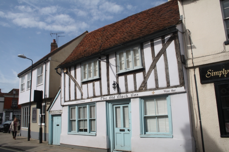
Entry Name: No. 1, CHURCH STREET
Listing Date: 6 September 1988
Grade: II
Source: Historic England
Source ID: 1168545
English Heritage Legacy ID: 116065
ID on this website: 101168545
Location: Coggeshall, Braintree, Essex, CO6
County: Essex
District: Braintree
Civil Parish: Coggeshall
Built-Up Area: Coggeshall
Traditional County: Essex
Lieutenancy Area (Ceremonial County): Essex
Church of England Parish: Coggeshall with Markshall
Church of England Diocese: Chelmsford
Tagged with: Architectural structure
This list entry was subject to a Minor Amendment on 02/11/2016
TL 8422-8522
9/34
COGGESHALL,
CHURCH STREET (north-west side),
No. 1
(Formerly listed as: No. 1 (John Smith Antiques)
GV
II
House, now commercial. Late C15, altered in C19. Timber framed, plastered with
some exposed framing, roofed with handmade red plain tiles. 2-bay main range
facing SE, with C19 stack at rear of left bay, C16/17 stack at rear of right
bay, and 2-bay wing to rear of it. Single-storey lean-to extensions at left end
and to rear of left bay (the latter forming a catslide), and C20 flat-roofed
extension beyond rear wing. 2 storeys. Ground floor, one late C19 tripartite
sash of 2:3:2 lights, and one late C19 sash of 4 lights. First floor, 2 C19
casements in original framed apertures. Half-glazed 4-panel door. Full-length
underbuilt jetty, the jetty plate mainly boxed in. Framing exposed on upper
storey, with curved tension braces trenched outside studding, nearly all
original. Wrought iron bracket for former inn sign. Moulded wooden eaves
cornice. One plain bracket below jetty at right end, inside. Similar curved
bracing trenched outside studs in both side walls, not exposed externally. On
both storeys the studding of internal partitions has been removed. Hearths
blocked. Complete crown-post roof with axial bracing. At the left end of the
upper storey the wattle and daub infill has been removed, exposing a post and
line of studs beyond, remaining from a building which formerly abutted to the
left, demolished to build a fire station, itself now replaced.
Formerly the Plough and Sails Inn, later the Black Boy Inn, closed in early C20, later known as Manchester House. RCHM 20.
Listing NGR: TL8504122633
External links are from the relevant listing authority and, where applicable, Wikidata. Wikidata IDs may be related buildings as well as this specific building. If you want to add or update a link, you will need to do so by editing the Wikidata entry.


Other nearby listed buildings
