Approximate Location Map
Large Map »
Latitude: 50.8442 / 50°50'39"N
Longitude: -3.6096 / 3°36'34"W
OS Eastings: 286775
OS Northings: 106196
OS Grid: SS867061
Mapcode National: GBR LB.W5DT
Mapcode Global: FRA 36BV.TVP
Plus Code: 9C2RR9VR+M5
Entry Name: Cheriton Primary School
Listing Date: 26 August 1965
Grade: II
Source: Historic England
Source ID: 1170450
English Heritage Legacy ID: 96471
ID on this website: 101170450
Location: Cheriton Fitzpaine, Mid Devon, EX17
County: Devon
District: Mid Devon
Civil Parish: Cheriton Fitzpaine
Built-Up Area: Cheriton Fitzpaine
Traditional County: Devon
Lieutenancy Area (Ceremonial County): Devon
Church of England Parish: Cheriton Fitzpaine
Church of England Diocese: Exeter
Tagged with: School building Thatched building
CHERITON FITZPAINE CHERITON FITZPAINE
SS 80 NE
7/19
- Cheriton Primary School
26.8.65
- II
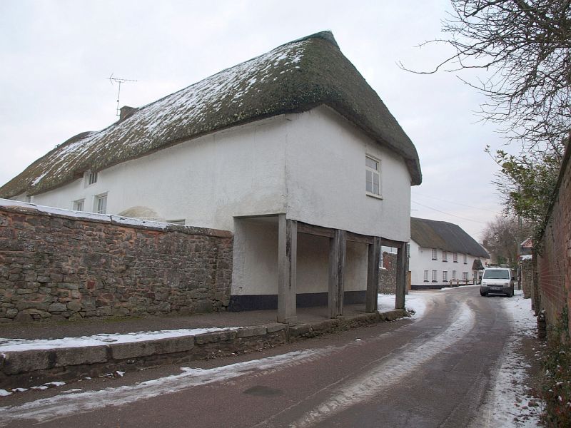
School, formerly Poorhouse. C18 and C19, converted to school in C20. Plastered cob
and rubble; rubble and brick stacks topped with C20 brick; thatched roof. Long
building fronting onto the Church of St Matthew's graveyard to the west. At the
right (south) end the first floor room extends over the street carried on an arcade
of timber posts. The rest comprises 5 classrooms. Mostly single storey. Irregular
8-window west front. Main door is set left of centre. It is C20, set high in wall
and reached by a flight of volcanic stone steps with rubble walls which curve out to
circular-section piers; the ashlar coping is weathered slightly on each side.
Secondary door immediately to left. Most of windows are tall C20 casements, the 2
towards right have mid C20 brick surrounds. Near right end is a curving oven
projection from a disused C18 or C19 stack. The ridge and eaves rise a little left
of centre and dip again near left end. Gable-ended left (north) end over exposed
rubble end wall with C20 brick dressings. Roof hipped to right (south). First floor
includes single C20 iron-framed casement with glazing bars and the 4 plain posts of
the arcade rest on volcanic stone pads now included in the kerb of the pavement. The
posts are now strengthened with C20 uprights. Rear (east) elevation includes another
series of tall C20 windows with glazing bars arranged in the same irregular rhythm as
the west front. Interior result of C20 conversion to school.
This is thought to be the longest thatch-roofed building in Gt Britain. According to
Church Commissioners' report of 1818 the building was then a school and poor-house
Source: Devon SMR
Listing NGR: SS8677606189
External links are from the relevant listing authority and, where applicable, Wikidata. Wikidata IDs may be related buildings as well as this specific building. If you want to add or update a link, you will need to do so by editing the Wikidata entry.


Other nearby listed buildings
