Approximate Location Map
Large Map »
Latitude: 51.7828 / 51°46'57"N
Longitude: -2.0537 / 2°3'13"W
OS Eastings: 396393
OS Northings: 209347
OS Grid: SO963093
Mapcode National: GBR 2NQ.3MP
Mapcode Global: VHB29.CG55
Plus Code: 9C3VQWMW+4G
Entry Name: Barn Approximately 3M North West of Croft Farmhouse
Listing Date: 4 June 1952
Last Amended: 24 June 1985
Grade: II
Source: Historic England
Source ID: 1172347
English Heritage Legacy ID: 127242
ID on this website: 101172347
Location: Winstone, Cotswold, Gloucestershire, GL7
County: Gloucestershire
District: Cotswold
Civil Parish: Winstone
Traditional County: Gloucestershire
Lieutenancy Area (Ceremonial County): Gloucestershire
Church of England Parish: Winstone St Bartholomew
Church of England Diocese: Gloucester
Tagged with: Barn
SO 90 NE WINSTONE CHURCH LANE
(south side)
6/142 Barn approximately 3m north west
of Croft Farmhouse
4.6.52 (previously listed as Barn to
West of Croft Farmhouse)
GV II
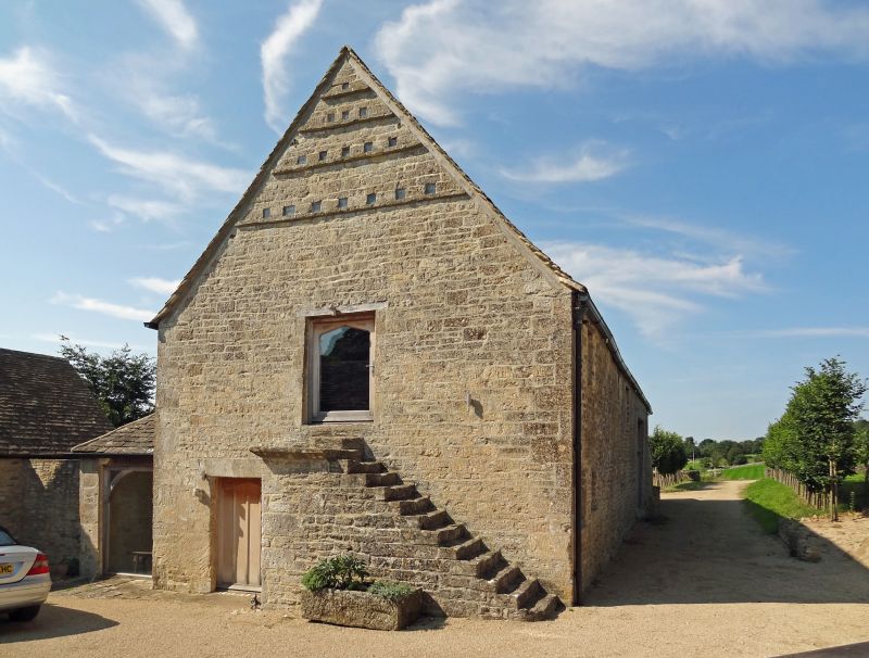
Barn and dovecot. Early C18. Random rubble limestone; stone slate
roof. Barn with 7 bays and south facing porch; loft over at east
end with external stone steps; dovecot at east end over. East
gable end: stone steps leading to doorway have nosing toupper
landing; plank loft door with timber lintel; 4 rows of pigeon holes
in gable with perches; plank door with deep stone lintel to left of
steps; opening to underside of steps. Gabled south porch has plank
barn doors and timber lintel; weather-boarded gable. Continuous
outshut runs to right with lean-to roof, hipped at east end; 2
plank doors and small windows, all with timber lintels; large
plank doors on east end return of outshut. North side has large
barn doorway with timber lintel opposite south porch; 2 small
windows at high level with timber lintels. Tie-beam and collar
truss roof with 2 rows of purlins. Stone threshing floor between
barn doorways with transverse ridges about 1m apart.
Listing NGR: SO9638609348
External links are from the relevant listing authority and, where applicable, Wikidata. Wikidata IDs may be related buildings as well as this specific building. If you want to add or update a link, you will need to do so by editing the Wikidata entry.


Other nearby listed buildings
