Approximate Location Map
Large Map »
Latitude: 51.6891 / 51°41'20"N
Longitude: -0.2457 / 0°14'44"W
OS Eastings: 521363
OS Northings: 200385
OS Grid: TL213003
Mapcode National: GBR 97.2R0
Mapcode Global: VHGPY.PTH0
Plus Code: 9C3XMQQ3+JP
Entry Name: Barn and Stables About 30 Metres North East of Ridge Farm House
Listing Date: 12 August 1985
Grade: II
Source: Historic England
Source ID: 1175248
English Heritage Legacy ID: 164300
ID on this website: 101175248
Location: Ridge, Hertsmere, Hertfordshire, EN6
County: Hertfordshire
District: Hertsmere
Civil Parish: Ridge
Built-Up Area: South Mimms
Traditional County: Hertfordshire
Lieutenancy Area (Ceremonial County): Hertfordshire
Church of England Parish: Ridge
Church of England Diocese: St.Albans
Tagged with: Barn
TL 20 SW RIDGE CROSS OAKS LANE
(North side)
Ridge
4/246 Barn and Stables about
- 30m NE of Ridge Farm House
GV II
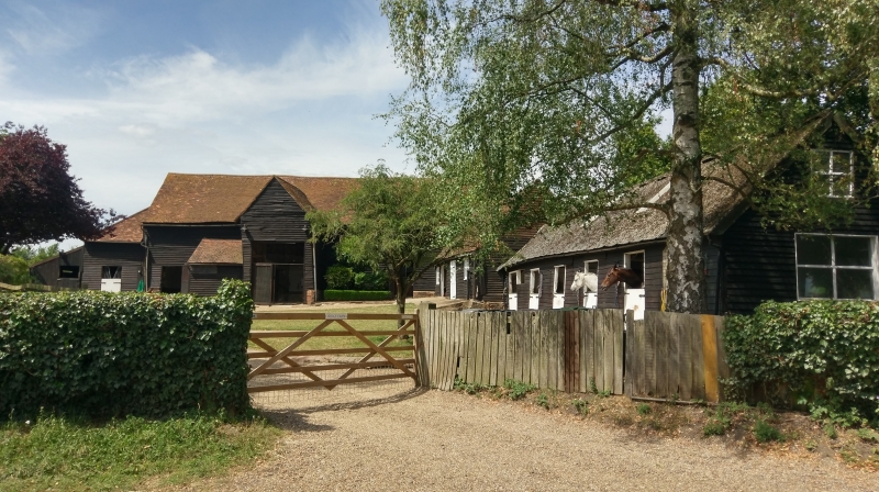
Barn. C18. Timber frame, weatherboarded. Brick base. Steeply pitched
tiled roof, machine tiles to rear. 6 bays. Entrance to left of centre in
tall gabled threshing bay to yard. Interior: queen struts to principals.
Butt purlins. Straight braces from jowled posts to straight tie beams.
Small braces from wall posts to wall plate in entrance bay. Lean-to
extensions to front and left. Attached stables extend forward to road
from right end of barn. C18 and C19. Timber frame, weatherboarded. Tiled
and corrugated asbestos roofs. 3 bays nearest barn are C18. Interior:
clasped purlins with curved braces from posts to tie beams. 6 bays
nearest road are C19, similar construction.
Listing NGR: TL2136300385
External links are from the relevant listing authority and, where applicable, Wikidata. Wikidata IDs may be related buildings as well as this specific building. If you want to add or update a link, you will need to do so by editing the Wikidata entry.


Other nearby listed buildings
