Approximate Location Map
Large Map »
Latitude: 51.9886 / 51°59'19"N
Longitude: -0.1913 / 0°11'28"W
OS Eastings: 524296
OS Northings: 233787
OS Grid: TL242337
Mapcode National: GBR J6Y.6GS
Mapcode Global: VHGNM.M8RV
Plus Code: 9C3XXRQ5+FF
Entry Name: Bury House
Listing Date: 8 November 1949
Grade: II
Source: Historic England
Source ID: 1175607
English Heritage Legacy ID: 161668
ID on this website: 101175607
Location: Baldock, North Hertfordshire, SG7
County: Hertfordshire
District: North Hertfordshire
Electoral Ward/Division: Baldock Town
Parish: Non Civil Parish
Built-Up Area: Baldock
Traditional County: Hertfordshire
Lieutenancy Area (Ceremonial County): Hertfordshire
Church of England Parish: Baldock
Church of England Diocese: St.Albans
Tagged with: House
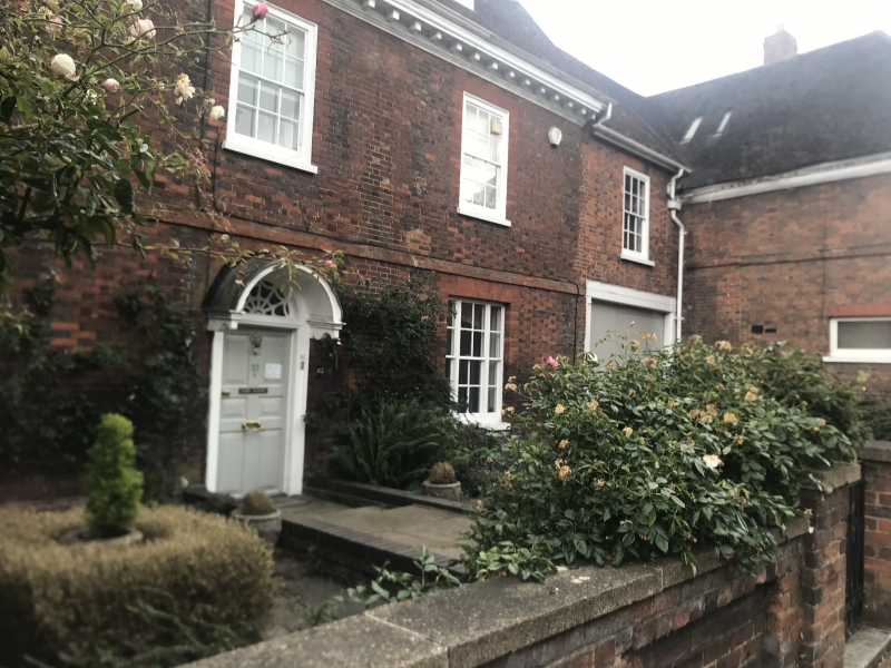
HITCHIN STREET
1. (South East Side)
5255 -----------------
TL 2433 NW 1/27 No 33A (Bury House)
6.11.49.
II GV
2.
First half of C18. Chequered red and grey brickwork, tiled roof with
modillioned wooden cornice and 2 leaded 2 light box casement dormers.
2 storeys and attics, first floor band. 7 sash windows with glazing bars
in broad flush frames. Ground floor has 2 triple light C19 sash windows.
Flat arches to all windows. 6 fielded panelled door and traceried fanlight
under semi-circular hood on console brackets.
Nos 1, 1B 3, 5, 7, 17, 19, 23, to 31, (odd), 31A, 33, 33A, 35 and 43 to 57
(odd) form a group.
Listing NGR: TL2432633783
External links are from the relevant listing authority and, where applicable, Wikidata. Wikidata IDs may be related buildings as well as this specific building. If you want to add or update a link, you will need to do so by editing the Wikidata entry.


Other nearby listed buildings
