Approximate Location Map
Large Map »
Latitude: 51.9696 / 51°58'10"N
Longitude: -0.3301 / 0°19'48"W
OS Eastings: 514811
OS Northings: 231439
OS Grid: TL148314
Mapcode National: GBR H5M.FCH
Mapcode Global: VHGNK.7RBH
Plus Code: 9C3XXM99+RX
Entry Name: Farmbuildings Fronting Road at Walnut Tree Farm
Listing Date: 24 October 1988
Grade: II
Source: Historic England
Source ID: 1175626
English Heritage Legacy ID: 163193
ID on this website: 101175626
Location: Pirton, North Hertfordshire, SG5
County: Hertfordshire
District: North Hertfordshire
Civil Parish: Pirton
Built-Up Area: Pirton
Traditional County: Hertfordshire
Lieutenancy Area (Ceremonial County): Hertfordshire
Church of England Parish: Pirton
Church of England Diocese: St.Albans
Tagged with: Agricultural structure
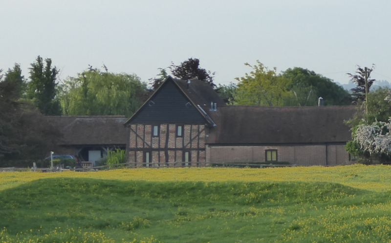
PIRTON WALNUT TREE ROAD
TL 1431 (South side)
7/183 Farmbuildings fronting
- road at Walnut Tree Farm
GV II
Farm buildings. C17 or earlier E range, lower C18 N range. Timber framed
on brick sills, the E range with dark weatherboarding to N and S ends
and W side but exposed frame on much of E side with sandy red brick
infill. The rear N wall of the N range facing the lane to N is of
chequered red and black brickwork with a course of clunch masonry at
the eaves. Corrugated asbestos roof to E range, red tiles to N range
which is open fronted on S. An L-shaped group at entrance to yard with
higher E range of barns and store houses facing E. Lower open fronted
6-bays cattle shed adjoining at NW and extending to W with backwall on
roadside. The barn at N part of E range has jowled posts, unjowled
mid-bay posts, mid-height rail jointed in-line, and straight tension
braces. Vent holes in N gable.
Listing NGR: TL1481131439
External links are from the relevant listing authority and, where applicable, Wikidata. Wikidata IDs may be related buildings as well as this specific building. If you want to add or update a link, you will need to do so by editing the Wikidata entry.


Other nearby listed buildings
