Approximate Location Map
Large Map »
Latitude: 50.9216 / 50°55'17"N
Longitude: -0.1314 / 0°7'52"W
OS Eastings: 531437
OS Northings: 115231
OS Grid: TQ314152
Mapcode National: GBR JMZ.3MG
Mapcode Global: FRA B6MN.SRP
Plus Code: 9C2XWVC9+JF
Entry Name: The Greyhound Public House
Listing Date: 11 May 1983
Grade: II
Source: Historic England
Source ID: 1180587
English Heritage Legacy ID: 302664
Also known as: The Greyhound, Hassocks
The Greyhound
ID on this website: 101180587
Location: Keymer, Mid Sussex, BN6
County: West Sussex
District: Mid Sussex
Civil Parish: Hassocks
Built-Up Area: Hurstpierpoint
Traditional County: Sussex
Lieutenancy Area (Ceremonial County): West Sussex
Church of England Parish: Clayton with Keymer
Church of England Diocese: Chichester
Tagged with: Pub
KEYMER KEYMER ROAD
1.
5405
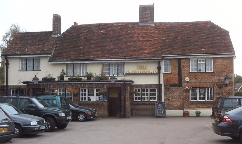
The Greyhound Public House
TQ 31 NW 20/50
II
2.
C17 or earlier timber-framed building, now mostly faced with red brick but the
timbering exposed in one place. Half-hipped tiled roof. Casement windows.
Two storeys. Four windows.
Listing NGR: TQ3143715231
External links are from the relevant listing authority and, where applicable, Wikidata. Wikidata IDs may be related buildings as well as this specific building. If you want to add or update a link, you will need to do so by editing the Wikidata entry.


Other nearby listed buildings
